Category:Mendocino in the 19th century
Jump to navigation
Jump to search
Media in category "Mendocino in the 19th century"
The following 24 files are in this category, out of 24 total.
-
 MendocinoLodgeNo179in1896.png 409 × 248; 107 KB
-
-

-
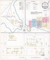
 Sanborn Fire Insurance Map from Mendocino, Mendocino County, California. LOC sanborn00678 001-1.tif 6,450 × 7,650; 141.17 MB
-

-
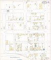
 Sanborn Fire Insurance Map from Mendocino, Mendocino County, California. LOC sanborn00678 001-2.tif 6,450 × 7,650; 141.17 MB
-

-
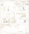
 Sanborn Fire Insurance Map from Mendocino, Mendocino County, California. LOC sanborn00678 001-3.tif 6,450 × 7,650; 141.17 MB
-

-
 Sanborn Fire Insurance Map from Mendocino, Mendocino County, California. LOC sanborn00678 001-4.tif 6,450 × 7,650; 141.17 MB
-

-
 Sanborn Fire Insurance Map from Mendocino, Mendocino County, California. LOC sanborn00678 002-1.tif 6,450 × 7,650; 141.17 MB
-

-
 Sanborn Fire Insurance Map from Mendocino, Mendocino County, California. LOC sanborn00678 002-2.tif 6,450 × 7,650; 141.17 MB
-

-
 Sanborn Fire Insurance Map from Mendocino, Mendocino County, California. LOC sanborn00678 002-3.tif 6,450 × 7,650; 141.17 MB
-

-
 Sanborn Fire Insurance Map from Mendocino, Mendocino County, California. LOC sanborn00678 002-4.tif 6,450 × 7,650; 141.17 MB
-

-
 Sanborn Fire Insurance Map from Mendocino, Mendocino County, California. LOC sanborn00678 002-5.tif 6,450 × 7,650; 141.17 MB
-

-
 Sanborn Fire Insurance Map from Mendocino, Mendocino County, California. LOC sanborn00678 002-6.tif 6,450 × 7,650; 141.17 MB
-

-
 Sanborn Fire Insurance Map from Mendocino, Mendocino County, California. LOC sanborn00678 002-7.tif 6,450 × 7,650; 141.17 MB


