Category:Meybille Bay
Jump to navigation
Jump to search
| Object location | | View all coordinates using: OpenStreetMap |
|---|
bay on the West Coast of New Zealand  | |||||
| Upload media | |||||
| Instance of | |||||
|---|---|---|---|---|---|
| Location |
| ||||
 | |||||
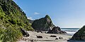
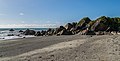
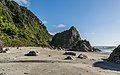
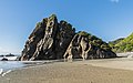
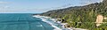
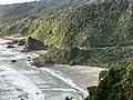
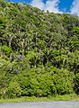
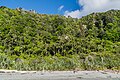
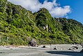
Meybille Bay, on the West Coast of New Zealand's South Island, is between Greymouth and Westport. It appears on an early map as 'Mabel' Bay, and has also been known as Maybelle Bay. and Mabelle Bay. Mark Pickering in The Coastal Journey (1993) claims it should actually be 'Mabille' Bay, after the Austrian surveyor Theophilus Mabille. Reed and Dowling in Place Names of New Zealand (2010) say it is named after successful French prospector Jean François Meybille, who died in a shipwreck on the return to France.
Media in category "Meybille Bay"
The following 27 files are in this category, out of 27 total.
-
 Meybille Bay 01.jpg 4,211 × 2,089; 6.37 MB
-
 Meybille Bay 02.jpg 5,046 × 2,563; 10.03 MB
-
 Meybille Bay 03.jpg 4,834 × 3,010; 11.35 MB
-
 Meybille Bay 04.jpg 4,253 × 2,488; 7.93 MB
-
 Meybille Bay 05.jpg 4,332 × 2,541; 9.46 MB
-
 Meybille Bay 06.jpg 4,285 × 2,671; 9.27 MB
-
 Meybille Bay 07.jpg 4,938 × 2,851; 9.28 MB
-
 Meybille Bay 08.jpg 4,244 × 2,783; 9.72 MB
-
 Meybille Bay 09.jpg 4,922 × 2,615; 8.75 MB
-
 Meybille Bay 10.jpg 3,027 × 4,541; 11.91 MB
-
 Meybille Bay 11.jpg 3,148 × 4,401; 13.44 MB
-
 Meybille Bay 12.jpg 4,346 × 2,831; 11.13 MB
-
 Meybille Bay 13.jpg 4,415 × 1,554; 5.65 MB
-
 Meybille Bay 14.jpg 4,241 × 2,058; 7.05 MB
-
 Meybille Bay 15.jpg 4,920 × 1,379; 5.29 MB
-
 Meybille Bay 16.jpg 4,488 × 2,377; 6.01 MB
-
 Meybille Bay 17.jpg 5,501 × 2,594; 10.73 MB
-
 Meybille Bay MRD 01.jpg 4,032 × 3,024; 2.58 MB
-
 Meybille Bay MRD 02.jpg 4,032 × 3,024; 3.42 MB
-
 Meybille Bay MRD 03.jpg 4,008 × 3,006; 2.51 MB
-
 Meybille Bay MRD 04.jpg 3,519 × 2,666; 2.55 MB
-
 Meybille Bay.jpg 4,452 × 2,960; 11.47 MB
-
 Rainforest at Meybille Bay 01.jpg 2,312 × 3,163; 9.38 MB
-
 Rainforest at Meybille Bay 02.jpg 3,651 × 2,760; 12.3 MB
-
 Rainforest at Meybille Bay 03.jpg 4,790 × 3,193; 16.89 MB
-
 Rainforest at Meybille Bay 04.jpg 4,718 × 3,234; 15.62 MB
-
 Rainforest at Meybille Bay 05.jpg 4,060 × 2,920; 12.59 MB


