Category:Midden-Drenthe
Jump to navigation
Jump to search
municipality of the Netherlands    .svg) | |||||
| Upload media | |||||
| Pronunciation audio | |||||
|---|---|---|---|---|---|
| Instance of |
| ||||
| Location | Drenthe, Netherlands | ||||
| Headquarters location | |||||
| Inception |
| ||||
| Population |
| ||||
| Area |
| ||||
| Elevation above sea level |
| ||||
| official website | |||||
 | |||||
Subcategories
This category has the following 8 subcategories, out of 8 total.
B
G
H
N
P
S
T
Media in category "Midden-Drenthe"
The following 46 files are in this category, out of 46 total.
-

-
-
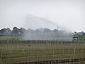
 A field sprayer in the field between Smildeand Hooghalen; Midden-Drenthe 2012.jpg 3,456 × 2,592; 5.78 MB
-
 A fresh-prepared agriculture field for crops in Drenthe - North Netherlands, May 2012.jpg 3,456 × 2,592; 7.01 MB
-

-
-

-

-

-
 A pile of grass bales in plastic under the shadow of trees; North-Netherlands, 2012.jpg 3,456 × 2,592; 5.42 MB
-

-

-
 A view on agriculture fields in the spring of 2012. Midden-Drenthe - The Netherlands.jpg 3,456 × 2,592; 8.45 MB
-

-
 A view over prepared agriculture fields in Drenthe, North-Netherlands, in spring of 2012.jpg 3,456 × 2,592; 5.76 MB
-

-
 A view over the fields of Laaghalerveen, direction Smilde; The Netherlands, Spring 2012.jpg 3,456 × 2,592; 8.18 MB
-

-
 Alting.jpg 3,264 × 2,448; 2.36 MB
-
 Amerdiep Aa en Hunze.jpg 1,296 × 972; 284 KB
-
 Beilervaart bij Hijkerbrug.jpg 1,296 × 972; 218 KB
-
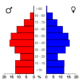 Bevolkingspiramide - Gemeente Midden-Drenthe (2007).png 350 × 370; 7 KB
-
-
 Brunsting.jpg 3,264 × 2,448; 2.86 MB
-
 Carved meadows in Midden-Drenthe.jpg 3,456 × 2,592; 7.18 MB
-
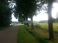
 Concrete path through the meadows near Hooghalen.jpg 2,592 × 3,456; 5.5 MB
-
 Essent Milieu Wijster Fruggo.jpg 800 × 600; 88 KB
-
 First draft.jpg 3,024 × 3,024; 2.02 MB
-
 Flowering cow parsley along the field.jpg 3,456 × 2,592; 8.59 MB
-
 Fresh mowed grass fields in Drenthe.jpg 3,456 × 2,592; 6.25 MB
-
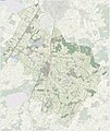 Gem-MiddenDrenthe-OpenTopo.jpg 8,547 × 10,161; 9.07 MB
-
 Landgoed Oosthalen.jpg 3,264 × 2,448; 3.02 MB
-
 Large field prepared and sown in - near Smilde, Midden-Drenthe, Netherlands.jpg 3,456 × 2,592; 4.9 MB
-
 Mowed grass fields with flowering cow parsley.jpg 2,592 × 3,456; 7.6 MB
-
Nl-Midden-Drenthe.oga 2.2 s; 37 KB
-
Nl-Midden-Drenthe.ogg 1.9 s; 22 KB
-
 Oranje kombord.png 701 × 701; 1,016 KB
-
 Oranjekanaal tussen Oranje en Hijken.jpg 1,238 × 902; 239 KB
-

-
 Plows on a barnyard in Laaghalerveen - Netherlands, Spring of 2012.jpg 3,456 × 2,592; 5.89 MB
-
 Rheeveld.jpg 3,264 × 2,448; 1.81 MB
-
 Tractor parked near the barn, with flowers in the berm, spring 2012.jpg 3,456 × 2,592; 5.54 MB
-
 Tractor tracks in the dry fields, Drenthe.jpg 2,592 × 3,456; 8.28 MB
-
 Tractor Tracks in the fields - rural landscape.jpg 2,592 × 3,456; 6.82 MB
-
 Tractor with barn, in the fields of Drenthe, The Netherlands.jpg 3,456 × 2,592; 5.75 MB
-
 Zuidveld.jpg 3,264 × 2,448; 2.12 MB


.png)


