Category:Middenwolderweg 4, Staphorst
Jump to navigation
Jump to search
| Object location | | View all coordinates using: OpenStreetMap |
|---|
 | |||||
| Upload media | |||||
| Instance of | |||||
|---|---|---|---|---|---|
| Location | Staphorst, Overijssel, Netherlands | ||||
| Street address |
| ||||
| Located on street |
| ||||
| Heritage designation |
| ||||
 | |||||
|
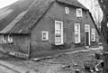
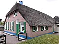
This is a category about rijksmonument number 34290
|
| Address |
|
Media in category "Middenwolderweg 4, Staphorst"
The following 4 files are in this category, out of 4 total.
-
 Aanzicht - Staphorst - 20204359 - RCE.jpg 1,200 × 814; 314 KB
-
 Linker zij- en achtergevel - Staphorst - 20204361 - RCE.jpg 1,188 × 1,200; 294 KB
-
 Staphorst - Middenwolderweg 4 RM34290.JPG 4,497 × 3,372; 3.63 MB
-
 Voor- en rechter zijgevel - Staphorst - 20204360 - RCE.jpg 1,192 × 1,200; 311 KB


