Category:Molatobel
Jump to navigation
Jump to search
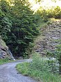
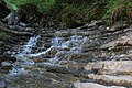
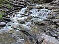
Deutsch: Das Molatobel (auch teilweise als Valmala bezeichnet) ist ein etwa 2 Kilometer langes Seitental des Frödischtals auf der Schattenseite des Frödischtals (nach Süden). Es beginnt in etwa 1343 m.ü.A. und endet im Frödischtal auf etwa 679 m.ü.A (18,37° Gefälle bzw. 33,2%). Der Begriff "Valmala" stammt aus dem Rätoromanischen und bedeutet "schlechtes Tal".
English: The "Molatobel" (also partially called "Valmala") is an approximately 2 km long side valley of the Frödischtal (valley) on the shadow side of the Frödischtal (to the south). It starts around 1343 masl and ends in the Frödischtal at about 679 masl (18.37 ° gradient or 33.2%). The term "Valmala" comes from the Romansh and means "bad valley".
Français : Le "Molatobel" (également partiellement appelé "Valmala") est une vallée latérale d'environ 2 km de long de la Frödischtal (vallée) sur le côté ombragé de la Frödischtal (au sud). Il commence vers 1343 mètres d'altitude et se termine dans le Frödischtal à environ 679 mètres d'altitude (gradient de 18,37 ° ou 33,2%). Le terme "Valmala" vient du romanche et signifie "mauvaise vallée".
An uninhabited valley in the municipality of Zwschenwasser, Vorarlberg, Austria  | |||||
| Upload media | |||||
| Instance of | |||||
|---|---|---|---|---|---|
| Location | Zwischenwasser, Feldkirch District, Vorarlberg, Austria | ||||
| Elevation above sea level |
| ||||
 | |||||
Media in category "Molatobel"
The following 13 files are in this category, out of 13 total.
-
 Dafins-Molatobel-01ASD.jpg 4,592 × 3,056; 7.28 MB
-
 Dafins-Molatobel-02ASD.jpg 4,592 × 3,056; 8.19 MB
-
 Dafins-Molatobel-03ESD.jpg 3,456 × 4,608; 3.08 MB
-
 Dafins-Molatobel-06ASD.jpg 3,056 × 4,592; 2.74 MB
-
 Dafins-Molatobel-07ESD.jpg 3,456 × 4,608; 2.03 MB
-
 Dafins-Molatobel-09ESD.jpg 3,456 × 4,608; 1.75 MB
-
 Dafins-Molatobel-10ESD.jpg 3,456 × 4,608; 2.76 MB
-
 Dafins-Molatobel-11ASD.jpg 4,592 × 3,056; 8.38 MB
-
 Dafins-Molatobel-12ASD.jpg 4,592 × 3,056; 7.84 MB
-
 Dafins-Molatobel-13ESD.jpg 4,608 × 3,456; 6.74 MB
-
 Dafins-Molatobel-14ESD.jpg 3,456 × 4,608; 2.62 MB
-
 Dafins-Molatobel-15ESD.jpg 3,456 × 4,608; 2.5 MB
-
 Dafins-Molatobel-17ESD.jpg 4,608 × 3,456; 2.13 MB


