Category:Molen O-N
Jump to navigation
Jump to search
| Object location | | View all coordinates using: OpenStreetMap |
|---|
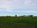
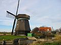
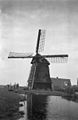
windmill in Schagerbrug, Netherlands  | |||||
| Upload media | |||||
| Instance of |
| ||||
|---|---|---|---|---|---|
| Location | Schagerbrug, Schagen, North Holland, Netherlands | ||||
| Street address |
| ||||
| Has use |
| ||||
| Heritage designation |
| ||||
| Source of energy | |||||
 | |||||
|
This is a category about rijksmonument number 41930
|
| Address |
|
Media in category "Molen O-N"
The following 15 files are in this category, out of 15 total.
-

-
-
-

-

-

-

-
 Close-up achtkante grondzeiler - AMR Molenfoto - 20539533 - RCE.jpg 1,200 × 900; 221 KB
-
 Schagerbrug - Molen Ooster-N.jpg 1,000 × 1,500; 875 KB
-
 Watermolen "O.N.", aanzicht - Zijpe - 20224186 - RCE.jpg 1,200 × 1,200; 230 KB
-
 Watermolen "O.N.", aanzicht - Zijpe - 20224187 - RCE.jpg 1,200 × 1,200; 215 KB
-
 Watermolen "O.N.", aanzicht - Zijpe - 20224188 - RCE.jpg 1,200 × 1,200; 186 KB
-
 Watermolen afdeling "O.N.", aanzicht - Zijpe - 20224189 - RCE.jpg 780 × 1,200; 150 KB
-
 Woonhuis bij achtkante grondzeiler - AMR Molenfoto - 20539527 - RCE.jpg 1,200 × 900; 195 KB
-
 Woonhuis bij achtkante grondzeiler - AMR Molenfoto - 20539530 - RCE.jpg 1,200 × 900; 265 KB


