Category:Molen van Boks
Jump to navigation
Jump to search
| Object location | | View all coordinates using: OpenStreetMap |
|---|
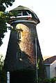
former windmill in Olst, Netherlands  | |||||
| Upload media | |||||
| Instance of | |||||
|---|---|---|---|---|---|
| Location | Olst, Overijssel, Netherlands | ||||
| Street address |
| ||||
| Has use | |||||
| Heritage designation |
| ||||
| Source of energy | |||||
 | |||||
|
This is a category about rijksmonument number 527605
|
| Address |
|
Media in category "Molen van Boks"
The following 3 files are in this category, out of 3 total.
-
 Molen zonder wieken - Olst - 20173044 - RCE.jpg 807 × 1,200; 198 KB
-
 Olst Molen Boks1.jpg 2,038 × 3,011; 688 KB
-
 Romp van ontwiekte voormalige korenmolen - Olst - 20367869 - RCE.jpg 1,200 × 1,190; 191 KB

