Category:Moresby Island (Haida Gwaii)
Jump to navigation
Jump to search
island in North Coast Regional District, British Columbia, Canada  | |||||
| Upload media | |||||
| Instance of | |||||
|---|---|---|---|---|---|
| Part of | |||||
| Location | British Columbia, Canada | ||||
| Located in or next to body of water | |||||
| Population |
| ||||
| Area |
| ||||
 | |||||
Subcategories
This category has the following 3 subcategories, out of 3 total.
M
- Moresby Camp (Haida Gwaii) (3 F)
- Mount Moresby (3 F)
S
Media in category "Moresby Island (Haida Gwaii)"
The following 12 files are in this category, out of 12 total.
-
 Admiralty Chart No 1923b Cape Caution to Port Simpson, Southern Portion, Published 1867.jpg 25,476 × 18,324; 41.43 MB
-
 AeroCamp.JPG 3,648 × 2,736; 2.27 MB
-
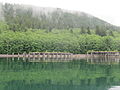
 Cecil Cove, Haida Gwaii.jpg 4,608 × 3,456; 7.46 MB
-
 Chopper View - panoramio.jpg 2,272 × 1,704; 917 KB
-
 Loc-QCS-Hecate-Dixon.png 415 × 510; 76 KB
-
 Locmap-QCS-Hecate-Dixon.png 415 × 510; 63 KB
-
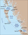
 Moresby Island BC.PNG 806 × 611; 36 KB
-
 Newcombe Peak - panoramio.jpg 3,264 × 2,448; 5.09 MB
-
 Sac Bay - panoramio.jpg 2,552 × 1,912; 1.85 MB
-
 Tasu Hidden Cabin - panoramio.jpg 3,264 × 2,176; 3.62 MB
-
 Tasu Mountain Range - panoramio.jpg 2,983 × 2,351; 3.66 MB
-
 Tasu Mountain View - panoramio.jpg 3,264 × 2,176; 1.87 MB


