Category:Moulin de l’Aile (Saint-Omer)
Jump to navigation
Jump to search
| Object location | | View all coordinates using: OpenStreetMap |
|---|
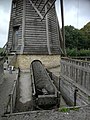
English: The Moulin de l'Aile was built in 1866. It allowed the draining of about 50 ha of marshland. At least 6 of these wooden mills existed on the Audomarois marsh. They were built on dykes which allowed to maintain a water level favourable to the culture of vegetables between March 1st and November 1st.
The wind mill was put into operation in March for 8 to 15 days and in summer after storms and heavy rain. The costs of the dewatering were borne by the owner as was the maintenance of the mill. The Moulin de l'Aile lost its wings after a strong gust of wind tore them off in July 1948.
Français : Le Moulin de l'Aile a été construit en 1866. Il permettait l'assèchement de 50 ha de marais environ. Au moins 6 de ces moulins en bois ont existé sur le marais audomarois. Ils étaient construits sur des digues qui permettait de maintenir un niveau d'eau favorable à la cuiture des légumes entre le 1er mars et 1er novembre.
Le moulin de l'aile était mis en service au mois de mars durant 8 à 15 jours et en été après les orages et les fortes pluies. Les coûts de l'assèchement était à la charge du propriétaire tout comme l'entretien du moulin. Le Moulin de l'Aile a perdu ses ailes à la suite d'une grosse bourrasque qui les lui a arraché en juillet 1948.
Media in category "Moulin de l’Aile (Saint-Omer)"
The following 7 files are in this category, out of 7 total.
-
 Moulin de l'Aile (rain) 1.jpg 1,836 × 3,264; 2.24 MB
-
 Moulin de l'Aile (rain) 2.jpg 1,836 × 3,264; 2.35 MB
-
 Moulin de l'Aile - Saint-Omer.jpg 2,304 × 3,456; 3.84 MB
-
 Moulin de l'Aile complete.jpg 1,200 × 1,600; 257 KB
-
 Moulin de l'Aile turn beam.jpg 1,836 × 3,264; 2.3 MB
-
 Moulin de l'Aile, archimedes' screw.jpg 1,200 × 1,600; 300 KB
-
 Moulin de l'Aile.jpg 3,456 × 2,304; 3.25 MB
_1.jpg)
_2.jpg)


