Category:Moustier train station
Jump to navigation
Jump to search
| Object location | | View all coordinates using: OpenStreetMap |
|---|
railway station in Belgium  | |||||
| Upload media | |||||
| Instance of | |||||
|---|---|---|---|---|---|
| Location | |||||
| Transport network | |||||
| Owned by | |||||
| Operator | |||||
| Date of official opening |
| ||||
| Elevation above sea level |
| ||||
| Connecting line | |||||
| Adjacent station |
| ||||
 | |||||
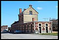
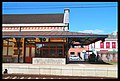
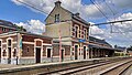
Français : La gare de Moustier est une gare ferroviaire belge de la ligne 130, de Namur à Charleroi, située à Moustier-sur-Sambre section de la commune de Jemeppe-sur-Sambre dans la province de Namur en région wallonne.
Nederlands: Station Moustier is een spoorwegstation langs spoorlijn 130 (Namen - Charleroi) in Moustier, een deelgemeente van Jemeppe-sur-Sambre. Men kan er kosteloos parkeren en er is een gratis fietsstalling.
Media in category "Moustier train station"
The following 23 files are in this category, out of 23 total.
-
 B - NMBS - 7.0. L.130 Km 74.80 - 2011-03-06 - Moustier (26940721667).jpg 3,166 × 4,750; 12.33 MB
-
 B - NMBS - 7.0. L.130 Km 74.80 - 2011-03-06 - Moustier (26940910287).jpg 4,942 × 3,326; 11.2 MB
-
 B - NMBS - 7.0. L.130 Km 74.80 - 2011-03-06 - Moustier (26941144407).jpg 4,682 × 3,151; 9.38 MB
-
 B - NMBS - 7.0. L.130 Km 74.80 - 2011-03-06 - Moustier (26941813887).jpg 4,942 × 3,326; 9.51 MB
-
 B - NMBS - 7.0. L.130 Km 74.80 - 2011-03-06 - Moustier (27941695928).jpg 3,953 × 2,660; 6.82 MB
-
 B - NMBS - 7.0. L.130 Km 74.80 - 2011-03-06 - Moustier (40002310820).jpg 4,942 × 3,326; 10.18 MB
-
 B - NMBS - 7.0. L.130 Km 74.80 - 2011-03-06 - Moustier (40910523615).jpg 4,942 × 3,326; 10.08 MB
-
 B - NMBS - 7.0. L.130 Km 74.80 - 2011-03-06 - Moustier (40910579715).jpg 4,942 × 3,326; 8.78 MB
-
 B - NMBS - 7.0. L.130 Km 74.80 - 2011-03-06 - Moustier (40910813705).jpg 4,942 × 3,326; 9.09 MB
-
 B - NMBS - 7.0. L.130 Km 74.80 - 2011-03-06 - Moustier (40910866995).jpg 4,312 × 2,902; 8.93 MB
-
 B - NMBS - 7.0. L.130 Km 74.80 - 2011-03-06 - Moustier (41091833254).jpg 4,942 × 3,326; 10.69 MB
-
 B - NMBS - 7.0. L.130 Km 74.80 - 2011-03-06 - Moustier (41767297782).jpg 3,982 × 2,681; 6.45 MB
-
 B - NMBS - 7.0. L.130 Km 74.80 - 2011-03-06 - Moustier (41767582062).jpg 4,942 × 3,326; 9.42 MB
-
 B - NMBS - 7.0. L.130 Km 74.80 - 2011-03-06 - Moustier (41767622522).jpg 4,496 × 3,026; 7.6 MB
-
 B - NMBS - 7.0. L.130 Km 74.80 - 2011-03-06 - Moustier (41808593531).jpg 4,744 × 3,151; 13.33 MB
-
 B - NMBS - 7.0. L.130 Km 74.80 - 2011-03-06 - Moustier (41808730151).jpg 4,942 × 3,326; 10.73 MB
-
 B - NMBS - 7.0. L.130 Km 74.80 - 2011-03-06 - Moustier (41808801661).jpg 4,942 × 3,326; 9.89 MB
-
 B - NMBS - 7.0. L.130 Km 74.80 - 2011-03-06 - Moustier (41809096471).jpg 4,942 × 3,326; 10.18 MB
-
 B - NMBS - 7.0. L.130 Km 74.80 - 2011-03-06 - Moustier (41809662551).jpg 4,942 × 3,326; 12.16 MB
-
 B - NMBS - 7.0. L.130 Km 74.80 - 2011-03-06 - Moustier (41809738271).jpg 4,725 × 3,180; 11.11 MB
-
 B - NMBS - 7.0. L.130 Km 74.80 - 2011-03-06 - Moustier (41809889321).jpg 4,684 × 3,153; 11.9 MB
-
 Gare de Moustier.jpg 512 × 384; 53 KB
-
 Station Moustier.jpg 3,706 × 2,085; 6.48 MB
.jpg)
.jpg)
.jpg)
.jpg)
.jpg)
.jpg)
.jpg)
.jpg)
.jpg)
.jpg)
.jpg)
.jpg)
.jpg)
.jpg)
.jpg)
.jpg)
.jpg)
.jpg)
.jpg)
.jpg)
.jpg)
