Category:Mull of Kintyre
Перейти до навігації
Перейти до пошуку
headland in Argyll and Bute, Scotland, UK  | |||||
| Завантажити медіафайл | |||||
| Є одним із | |||||
|---|---|---|---|---|---|
| Місце розташування | Аргайл-і-Б'ют, Шотландія | ||||
| Розташовується на водоймі | |||||
| Дата створення / заснування |
| ||||
| Не плутати з | |||||
 | |||||
Файли в категорії «Mull of Kintyre»
Показано 73 файли цієї категорії (із 73).
-
 A View To Fair Head In Fair Weather - geograph.org.uk - 3042859.jpg 3448 × 4592; 3,81 МБ
-
 Access Road To The Mull Of Kintyre Lighthouse - geograph.org.uk - 3042900.jpg 3448 × 4592; 3,73 МБ
-
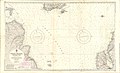 Admiralty Chart No 2199 North Channel Northern Part, Published 1966.jpg 18 326 × 11 113; 12,45 МБ
-
 Admiralty Chart No 2201 North Channel Mull of Kintyre to Belfast Lough, Published 1946.jpg 11 001 × 16 148; 44,88 МБ
-
 Admiralty Chart No 2515 Scotland west coast Mull of Cantyre to Ardnamurchan, Published 1868.jpg 10 249 × 12 652; 15,3 МБ
-
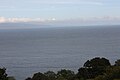
 Antrim Coast from Mull of Kintyre on a Sunny Day.jpg 1077 × 678; 588 КБ
-
 Cairngaan Mull of Kintyre geograph-3219372-by-Ben-Brooksbank.jpg 1701 × 1087; 1,6 МБ
-
 Car park at the Mull of Kintyre - geograph.org.uk - 3303757.jpg 640 × 427; 256 КБ
-
 Carrick-a-Rede panorama.jpg 5145 × 716; 749 КБ
-
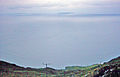
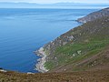 Coast near Mull of Kintyre lighthouse - geograph.org.uk - 3081369.jpg 800 × 600; 215 КБ
-
 Coolranny, County Antrim, September 2010 (02).JPG 4272 × 2848; 3,71 МБ
-

-
 Fence junction on Corr Bhan - geograph.org.uk - 1430536.jpg 640 × 428; 53 КБ
-
 Fence on Mull of Kintyre - geograph.org.uk - 3626086.jpg 1024 × 768; 183 КБ
-
 Gated road near Mull of Kintyre - geograph.org.uk - 1572004.jpg 640 × 480; 116 КБ
-
 Gated road to the Mull of Kintyre Lighthouse - geograph.org.uk - 3369676.jpg 1000 × 664; 177 КБ
-
 Grogport, Kintyre - geograph.org.uk - 36688.jpg 640 × 480; 92 КБ
-
 Hairpin bend on road to Mull of Kintyre lighthouse - geograph.org.uk - 1900902.jpg 2000 × 1501; 1,41 МБ
-

-
-
 Keil Caves - geograph.org.uk - 503999.jpg 640 × 479; 145 КБ
-

-
-
 Mist Closing In On The Mull Of Kintyre - geograph.org.uk - 3043035.jpg 4592 × 3448; 2,99 МБ
-
 Mist Rolling In From The Sea - geograph.org.uk - 3042921.jpg 4592 × 3448; 3 МБ
-
 Moorland, Mull of Kintyre - geograph.org.uk - 2926059.jpg 640 × 360; 214 КБ
-
 Mull of Kintyre from Machrie (Arran) - geograph.org.uk - 77295.jpg 640 × 480; 132 КБ
-
 Mull of Kintyre, a Jura view - geograph.org.uk - 3286646.jpg 640 × 481; 51 КБ
-
-

-
 Mull of Kintyre, another hairpin - geograph.org.uk - 3286642.jpg 640 × 480; 80 КБ
-
-
 Mull of Kintyre, view towards Sanda - geograph.org.uk - 3286671.jpg 640 × 480; 50 КБ
-
 Mull of Kintyre.jpg 3264 × 2448; 2,38 МБ
-

-
 North Channel and Mull of Kintyre, September 2010 (01).JPG 4272 × 2848; 3,29 МБ
-
 Ordnance Survey One-Inch Sheet 65 Kintyre, Published 1955.jpg 8585 × 10 706; 13,76 МБ
-
 Ordnance Survey One-Inch Sheet 76 Kintyre, Published 1925.jpg 10 558 × 15 392; 14,21 МБ
-
-
 Passing The Mull - geograph.org.uk - 3043106.jpg 3448 × 4592; 2,6 МБ
-
-
 Roadsign - geograph.org.uk - 2193620.jpg 640 × 482; 138 КБ
-

-
 Sailing on the North Channel - geograph.org.uk - 312647.jpg 640 × 410; 49 КБ
-
 Sailor grave Innean Bay, Mull of Kintyre. - geograph.org.uk - 62041.jpg 640 × 480; 128 КБ
-

-

-
 Sheep with view to Ireland, Mull of Kintyre - geograph.org.uk - 1900995.jpg 1280 × 960; 741 КБ
-
-
 South Point, Mull Of Kintyre - geograph.org.uk - 3042879.jpg 3448 × 4592; 3,92 МБ
-
 The Mull Of Kintyre From Corsewall Point - geograph.org.uk - 3078464.jpg 3448 × 4592; 1,61 МБ
-

-

-

-

-

-

-
 Track in Killypole Forest - geograph.org.uk - 738034.jpg 640 × 427; 223 КБ
-
 Turning area - geograph.org.uk - 2616964.jpg 640 × 427; 194 КБ
-

-

-

-

-

-

-

-
-
-

-

-
 Willow and heather, Mull of Kintyre - geograph.org.uk - 1900948.jpg 2000 × 1500; 2,6 МБ
-

-
 The road to the Mull of Kintyre. - geograph.org.uk - 138877.jpg 640 × 480; 79 КБ


.JPG)


_-_geograph.org.uk_-_77295.jpg)


.JPG)


