Category:National Cycle Network route 6 (Erewash)
Jump to navigation
Jump to search
National Cycle Network route 6 in the Borough of Erewash, Derbyshire.
Media in category "National Cycle Network route 6 (Erewash)"
The following 19 files are in this category, out of 19 total.
-
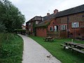 Cycle Route 6 entering Breaston behind 'The Navigation' - geograph.org.uk - 3185583.jpg 4,000 × 3,000; 4.6 MB
-
 Cycle Route 6 following the former Derby canal - geograph.org.uk - 3185560.jpg 4,000 × 3,000; 4.58 MB
-
 Cycle Route 6 near Draycot Fields Farm - geograph.org.uk - 3185570.jpg 4,000 × 3,000; 4.59 MB
-
 Cycle Route 6 on the edge of Breaston - geograph.org.uk - 3185578.jpg 4,000 × 3,000; 4.65 MB
-
 Cycle Route 6 through the centre of Long Eaton - geograph.org.uk - 3185731.jpg 4,000 × 3,000; 1.89 MB
-
 Cycle track, Draycott Fields - geograph.org.uk - 3572907.jpg 640 × 480; 72 KB
-
 Cycle trail heading east - geograph.org.uk - 3572910.jpg 640 × 480; 94 KB
-
 Cycle trail heading east - geograph.org.uk - 3572915.jpg 640 × 480; 87 KB
-
 Cycle trail heading east - geograph.org.uk - 3572920.jpg 640 × 480; 86 KB
-
 Derby Canal path, Breaston - geograph.org.uk - 5647487.jpg 1,280 × 859; 316 KB
-
 Millennium Milepost 267 - geograph.org.uk - 5499211.jpg 960 × 1,280; 506 KB
-
 National Cycle Network at the Erewash Canal-Derby Canal junction.JPG 4,608 × 3,440; 4.53 MB
-

-

-
 NCN Route 6 in West Park - geograph.org.uk - 5164034.jpg 1,280 × 1,280; 690 KB
-
 Path along the disused Derby Canal - geograph.org.uk - 5654161.jpg 800 × 550; 135 KB
-
 Route 6 Milepost - geograph.org.uk - 843669.jpg 427 × 640; 170 KB
-
 Sustrans Route 6 in West Park - geograph.org.uk - 1193387.jpg 640 × 480; 144 KB
-
 Temporary fencing on Route 6 - geograph.org.uk - 3147686.jpg 640 × 427; 162 KB


