Category:Natural Arch, Tirumala hills
natural arch in India  | |||||
| Upload media | |||||
| Instance of | |||||
|---|---|---|---|---|---|
| Location | Tirupati (Urban) mandal, Tirupati district, Andhra Pradesh, India | ||||
| Heritage designation |
| ||||
| Width |
| ||||
 | |||||
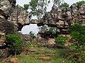
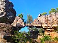
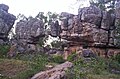
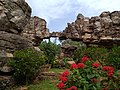
Natural Arch, Tirumala hills. The Arch is also called Silathoranam in local language (Telugu language: “Sila” means ‘rock’ and “thoranam” means a garland strung over a threshold, connecting two vertical columns or an ‘arch’ as in this case). The arch measures 8 m (26.2 ft) in width and 3 m (9.8 ft) in height, and is naturally formed in the quartzites of Cuddapah Supergroup of Middle to Upper Proterozoic (1600 to 570 Ma) due to natural erosive forces. In the 1980s, during excavations for a geological fault in the Tirumala hills, geologists found this rare geological formation of the rock arch which has two dissimilar sets of rocks with a connecting thin link. The assessed geological age of the rock arch is 1.5 billion years. Formation of the arch is attributed to intensified weathering and erosion of stream action that has withstood the torque of nature.This is a rare geological fault which is technically called in the geological idiom as Eparchaean Unconformity
Media in category "Natural Arch, Tirumala hills"
The following 11 files are in this category, out of 11 total.
-
 ArchatTirumala.JPG 640 × 480; 84 KB
-
 Hills and welcome Arch.jpg 480 × 640; 63 KB
-
 Natural Arch in Tirupati, Andhra Pradesh, India.jpg 4,350 × 2,850; 2.54 MB
-
 Natural stone arch in tirumala.JPG 2,592 × 1,944; 2.47 MB
-
 Sahaja Shila Thoranam @ Tirumala, AP.jpg 2,048 × 1,536; 398 KB
-
 Shila Thornanam - The Natural Arch.jpg 4,128 × 2,322; 2.33 MB
-
 Shilathoranam.jpg 1,184 × 720; 914 KB
-
 Silathoranam, Tirumala hills.jpg 4,208 × 2,368; 5.28 MB
-
 Silathoranam.jpg 800 × 526; 115 KB
-
 The natural arch.jpg 640 × 480; 164 KB
-
 TIRUPATI SILATORANAM.jpg 4,160 × 3,120; 2.42 MB


