Category:Nederlands Hervormde Kerk, Aartswoud
Jump to navigation
Jump to search
| Object location | | View all coordinates using: OpenStreetMap |
|---|
church building in Opmeer, Netherlands  | |||||
| Upload media | |||||
| Instance of | |||||
|---|---|---|---|---|---|
| Location | Aartswoud, Opmeer, North Holland, Netherlands | ||||
| Street address |
| ||||
| Located on street |
| ||||
| Heritage designation |
| ||||
| Inception |
| ||||
| Religion or worldview | |||||
| official website | |||||
 | |||||
Kerk:
|
This is a category about rijksmonument number 31783
|
Toren:
|
This is a category about rijksmonument number 31785
|
| Address |
|
Media in category "Nederlands Hervormde Kerk, Aartswoud"
The following 24 files are in this category, out of 24 total.
-
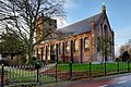
 0220180704 zicht op Aartswoud1 gezien vanuit-het oosten.jpg 5,184 × 3,456; 4.03 MB
-
 20180629 Zicht1 op Aartswoud.jpg 5,184 × 3,456; 3.64 MB
-
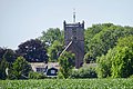 20180704 zicht op Aartswoud2 gezien vanuit-het oosten.jpg 5,061 × 3,374; 3.53 MB
-
 4520180629 Zicht2 op Aartswoud.jpg 5,184 × 3,456; 3.22 MB
-
 Aartswâld, tsjerke.jpg 2,717 × 1,808; 2.24 MB
-
 Heerenbank - Aartswoud - 20004043 - RCE.jpg 946 × 1,200; 247 KB
-
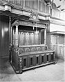
 Interieur, aanzicht orgel, orgelnummer 163 - Aartswoud - 20417391 - RCE.jpg 967 × 1,200; 219 KB
-
 Interieur, herenbank - Aartswoud - 20004045 - RCE.jpg 894 × 1,200; 209 KB
-
 Interieur, herenbank - Aartswoud - 20408891 - RCE.jpg 906 × 1,200; 252 KB
-
 Kerk Aartswoud vanuit het oosten.jpg 5,908 × 3,939; 17.92 MB
-
 Kerk Aartswoud.jpg 4,000 × 6,000; 15.88 MB
-
 Kerk en toren Aartswoud panorama.jpg 5,988 × 7,825; 33.96 MB
-
 Kerk en toren Aartswoud vanuit het zuidwesten.jpg 6,000 × 4,000; 18.47 MB
-
 Kerk en toren Aartswoud zicht vanuit noordoost.jpg 5,692 × 3,795; 17.93 MB
-
 Kerk en toren Aartswoud zicht vanuit noordwesten.jpg 5,955 × 3,970; 18.42 MB
-

-
 N.H.Kerk - Aartswoud - 20004044 - RCE.jpg 1,200 × 946; 290 KB
-
 NHChurch.Aartswoud.jpg 4,000 × 3,000; 6.59 MB
-

-
 Toegangspad en voordeur kerk Aartswoud.jpg 3,990 × 5,985; 17.27 MB
-
 Toren - Aartswoud - 20004046 - RCE.jpg 808 × 1,200; 174 KB
-
 Toren kerk tijdens restauratie - Aartswoud - 20318909 - RCE.jpg 884 × 1,200; 199 KB
-
 Tower.NHChurch.Aartswoud.jpg 3,000 × 4,000; 5.51 MB
-
 Tsjerke fan Aartswâld.jpg 2,252 × 2,251; 3.55 MB


