Category:Nederlands Hervormde Kerk (Giessen-Oudekerk)
Jump to navigation
Jump to search
| Object location | | View all coordinates using: OpenStreetMap |
|---|
 | |||||
| Upload media | |||||
| Instance of |
| ||||
|---|---|---|---|---|---|
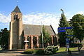
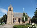
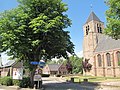
| Location | Giessenburg, South Holland, Netherlands | ||||
| Street address |
| ||||
| Located on street |
| ||||
| Heritage designation |
| ||||
 | |||||
Kerk:
|
This is a category about rijksmonument number 16115
|
Toren:
|
This is a category about rijksmonument number 16116
|
| Address |
|
Subcategories
This category has only the following subcategory.
Media in category "Nederlands Hervormde Kerk (Giessen-Oudekerk)"
The following 29 files are in this category, out of 29 total.
-
 En N.H. Kerk vanuit het zuid-oosten - Giessen-Oudekerk - 20078109 - RCE.jpg 873 × 1,200; 191 KB
-
 En N.H. Kerk vanuit het zuid-oosten - Giessen-Oudekerk - 20078110 - RCE.jpg 893 × 1,200; 187 KB
-
 En N.H. Kerk vanuit het zuid-westen - Giessen-Oudekerk - 20078108 - RCE.jpg 876 × 1,200; 201 KB
-
 En N.H.Kerk vanuit het noorden - Giessen-Oudekerk - 20078111 - RCE.jpg 1,200 × 876; 158 KB
-
 Exterieur vanuit het noord-westen - Giessen-Oudekerk - 20078117 - RCE.jpg 891 × 1,200; 209 KB
-
 Gevels - Giessen-Oudekerk - 20078156 - RCE.jpg 1,200 × 799; 170 KB
-
 Giessen-Oudekerk NH Kerk 1.jpg 3,768 × 3,392; 5.62 MB
-
 Giessen-Oudekerk NH Kerk 2.jpg 4,024 × 3,263; 4.98 MB
-
 Giessenburg - Oudkerkseweg 22 Nederlands Hervormde kerk.JPG 3,888 × 2,592; 6.92 MB
-
 Giessenburg 16116 - Oudkerkseweg bij 22 Kerktoren.JPG 2,592 × 3,888; 7.47 MB
-
 Kerk - Unknown - 20475063 - RCE.jpg 1,200 × 900; 152 KB
-
 Noordgevel en pastorie - Giessen-Oudekerk - 20078123 - RCE.jpg 1,200 × 951; 257 KB
-
 Oostgevel - Giessen-Oudekerk - 20078124 - RCE.jpg 948 × 1,200; 295 KB
-
 Oude balkresten - Giessen-Oudekerk - 20078115 - RCE.jpg 1,200 × 943; 291 KB
-
 Overzicht - Giessen-Oudekerk - 20078122 - RCE.jpg 1,200 × 955; 250 KB
-
 RM16115 - Kerk.jpg 2,592 × 1,944; 1.57 MB
-
 RM16116 - Kerktoren foto 1.jpg 1,944 × 2,592; 1.43 MB
-
 RM16116 - Kerktoren foto 2.jpg 2,592 × 1,944; 2.26 MB
-
 Schip vanuit het zuidoosten - Giessen - 20324191 - RCE.jpg 1,200 × 848; 182 KB
-
 Toegangshek - Giessen-Oudekerk - 20078132 - RCE.jpg 1,190 × 1,200; 474 KB
-
 Toegangshek - Giessen-Oudekerk - 20078133 - RCE.jpg 1,197 × 1,200; 438 KB
-
 Toegangshek - Giessen-Oudekerk - 20078134 - RCE.jpg 1,197 × 1,200; 422 KB
-
 Toren - Giessen-Oudekerk - 20078112 - RCE.jpg 958 × 1,200; 255 KB
-
 Toren - Giessen-Oudekerk - 20078113 - RCE.jpg 947 × 1,200; 225 KB
-
 Toren - Giessen-Oudekerk - 20078114 - RCE.jpg 946 × 1,200; 240 KB
-
 Voorbouw - Giessen-Oudekerk - 20078118 - RCE.jpg 1,200 × 911; 269 KB
-
 Westgevel - Giessen-Oudekerk - 20078125 - RCE.jpg 953 × 1,200; 351 KB
-
 Westgevel, kerktoren - Giessen-Oudekerk - 20078121 - RCE.jpg 894 × 1,200; 197 KB
-
 Zuidgevel - Giessen-Oudekerk - 20078126 - RCE.jpg 1,200 × 931; 242 KB


