Category:Nederlands Hervormde Kerk (Nigtevecht)
Jump to navigation
Jump to search
| Object location | | View all coordinates using: OpenStreetMap |
|---|
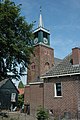
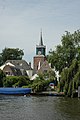
church building in Stichtse Vecht, Netherlands  | |||||
| Upload media | |||||
| Instance of | |||||
|---|---|---|---|---|---|
| Location | Nigtevecht, Utrecht, Netherlands | ||||
| Street address |
| ||||
| Located on street |
| ||||
| Heritage designation |
| ||||
| Religion or worldview | |||||
 | |||||
|
This is a category about rijksmonument number 30624
|
| Address |
|
Media in category "Nederlands Hervormde Kerk (Nigtevecht)"
The following 20 files are in this category, out of 20 total.
-
 Dorp, reproductie uit Verheerlijkt Nederland - Nigtevecht - 20166125 - RCE.jpg 1,200 × 808; 294 KB
-

-
 Exterieur OVERZICHT, ZUIDGEVEL, OOSTGEVEL - Nigtevecht - 20314248 - RCE.jpg 1,188 × 1,200; 291 KB
-
 Herenbank - Nigtevecht - 20166171 - RCE.jpg 1,200 × 967; 176 KB
-
 Herenbank - Nigtevecht - 20166172 - RCE.jpg 1,200 × 965; 156 KB
-

-
 Interieur naar het oosten - Nigtevecht - 20166174 - RCE.jpg 1,200 × 947; 320 KB
-
 Interieur naar het westen - Nigtevecht - 20166173 - RCE.jpg 965 × 1,200; 191 KB
-
 Linkerzijde - Nigtevecht - 20166197 - RCE.jpg 1,195 × 1,200; 330 KB
-
 Met Nederlands Hervormde Kerk, overzicht - Nigtevecht - 20166189 - RCE.jpg 1,200 × 944; 214 KB
-
 Nigtevecht - NH Kerk RM30624.JPG 4,075 × 3,095; 1.2 MB
-
 Nigtevecht - panoramio - Rokus C (2).jpg 2,000 × 3,008; 1.62 MB
-
 Nigtevecht - panoramio - Rokus C (3).jpg 2,000 × 3,008; 1.49 MB
-
 Nigtevecht - panoramio - Rokus C (4).jpg 2,000 × 3,008; 1.44 MB
-
 Noordgevel - Nigtevecht - 20166176 - RCE.jpg 1,200 × 946; 344 KB
-
 Overzicht (Kern) Dorpsstraat - Nigtevecht - 20166127 - RCE.jpg 1,195 × 1,200; 284 KB
-
 Overzicht (Kern) Dorpsstraat - Nigtevecht - 20166128 - RCE.jpg 1,200 × 1,197; 323 KB
-
 Toren - Nigtevecht - 20166177 - RCE.jpg 1,200 × 1,183; 337 KB
-
 Zuid-gevel - Nigtevecht - 20166175 - RCE.jpg 960 × 1,200; 194 KB
-
 Zuid-oost zijde exterieur - Nigtevecht - 20166178 - RCE.jpg 1,183 × 1,200; 268 KB


.jpg)
.jpg)
.jpg)

_Dorpsstraat_-_Nigtevecht_-_20166127_-_RCE.jpg)
_Dorpsstraat_-_Nigtevecht_-_20166128_-_RCE.jpg)


