Category:Nederlands Hervormde Kerk (Wilp)
Jump to navigation
Jump to search
| Object location | | View all coordinates using: OpenStreetMap |
|---|
church in Wilp, Netherlands  | |||||
| Upload media | |||||
| Instance of | |||||
|---|---|---|---|---|---|
| Location | Wilp, Gelderland, Netherlands | ||||
| Street address |
| ||||
| Located on street |
| ||||
| Heritage designation |
| ||||
| Inception |
| ||||
| Significant event |
| ||||
 | |||||
|
This is a category about rijksmonument number 38099
|
| Address |
|
Media in category "Nederlands Hervormde Kerk (Wilp)"
The following 18 files are in this category, out of 18 total.
-
 Detail Toren naar het zuid-westen - Wilp - 20214489 - RCE.jpg 943 × 1,200; 260 KB
-
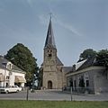
 Dorpsplein Wilp.jpg 4,320 × 3,240; 3.3 MB
-
 Interieur, overzicht koor - Wilp - 20375199 - RCE.jpg 1,200 × 1,196; 238 KB
-

-
 Kerk, inwendig - Wilp - 20214492 - RCE.jpg 941 × 1,200; 197 KB
-
 Kerk, inwendig - Wilp - 20214493 - RCE.jpg 957 × 1,200; 234 KB
-

-
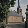
 Kerk, uitwendig - Wilp - 20214490 - RCE.jpg 940 × 1,200; 256 KB
-
 Kerk, uitwendig - Wilp - 20214491 - RCE.jpg 1,200 × 946; 355 KB
-
 Overzicht westgevel met kerktoren - Wilp - 20359684 - RCE.jpg 943 × 1,200; 202 KB
-
 Overzicht westgevel met kerktoren en omgeving - Wilp - 20375195 - RCE.jpg 1,200 × 1,200; 229 KB
-
 Overzicht zuidgevel met kerktoren - Wilp - 20375196 - RCE.jpg 1,200 × 1,200; 313 KB
-
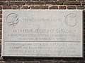 PlaquetteWilp 3127 22042014.jpg 2,816 × 2,112; 5.5 MB
-

-
 Toren naar het oosten - Wilp - 20214488 - RCE.jpg 948 × 1,200; 205 KB
-
 Toren vanuit het westen - Wilp - 20214487 - RCE.jpg 908 × 1,200; 243 KB
-
 Wilp kerk.jpg 743 × 991; 251 KB
-
 Zicht op de kerk, gezien vanuit het zuiden - Wilp - 20375197 - RCE.jpg 1,192 × 1,200; 315 KB


