Category:Nederlands Hervormde Kerk (Wormer)
Jump to navigation
Jump to search
| Object location | | View all coordinates using: OpenStreetMap |
|---|
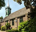
church in Wormer, Netherlands  | |||||
| Upload media | |||||
| Instance of | |||||
|---|---|---|---|---|---|
| Location | Wormer, North Holland, Netherlands | ||||
| Street address |
| ||||
| Heritage designation |
| ||||
 | |||||
|
This is a category about rijksmonument number 39524
|
| Address |
|
Media in category "Nederlands Hervormde Kerk (Wormer)"
The following 4 files are in this category, out of 4 total.
-
 Exterieur - Wormer - 20217392 - RCE.jpg 1,200 × 806; 215 KB
-
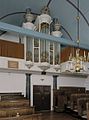 Interieur, aanzicht orgel, orgelnummer 1713 - Wormer - 20369445 - RCE.jpg 887 × 1,200; 164 KB
-
 Inwendig doophek - Wormer - 20217393 - RCE.jpg 1,200 × 956; 192 KB
-
 Wormer-Kerkstraat 8.jpg 2,019 × 1,794; 924 KB


