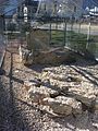
Category:Neolithisches Steinkistengrab (Rennimattstrasse 50, Laufen)
Jump to navigation
Jump to search
| Object location | | View all coordinates using: OpenStreetMap |
|---|
archaeological site in the canton of Basel-Landschaft, Switzerland  | |||||
| Upload media | |||||
| Instance of | |||||
|---|---|---|---|---|---|
| Part of | |||||
| Location | Laufen, Laufen District, Basel-Landschaft, Switzerland | ||||
| Street address |
| ||||
| Heritage designation | |||||
 | |||||
Media in category "Neolithisches Steinkistengrab (Rennimattstrasse 50, Laufen)"
This category contains only the following file.
-
 Dolmen Laufen.jpg 1,936 × 2,592; 1.18 MB