Category:Ng Wo Public Primary School
Jump to navigation
Jump to search
| Object location | | View all coordinates using: OpenStreetMap |
|---|
English: Ng Wo Public Primary School. The former school is adjacent to the villages Choi Uk Tsuen, Tai Wai Tsuen, Wong Uk Tsuen and Ying Lung Wai.
中文:五和公立學校
Media in category "Ng Wo Public Primary School"
The following 9 files are in this category, out of 9 total.
-
 HK NgWoPublicPrimarySchool.jpg 4,208 × 2,368; 2.6 MB
-
 Ng Wo Public Primary School 01.jpg 4,160 × 3,120; 6.01 MB
-
 Ng Wo Public Primary School in December 2023.jpg 4,000 × 3,000; 3.14 MB
-
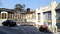
 Ng Wo Public School, Shap Pat Heung part 1 in January 2023.jpg 4,000 × 3,000; 3.21 MB
-
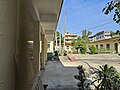
 Ng Wo Public School, Shap Pat Heung part 2 in January 2023.jpg 4,000 × 3,000; 3.23 MB
-
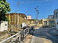
 Ng Wo Public School, Shap Pat Heung part 3 in January 2023.jpg 4,000 × 3,000; 3.45 MB
-
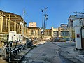
 Ng Wo Public School, Shap Pat Heung part 4 in January 2023.jpg 4,000 × 3,000; 3.48 MB
-
 Ng Wo Public School, Shap Pat Heung part 5 in January 2023.jpg 4,000 × 3,000; 3.09 MB
-
 Ng Wo Public School, Shap Pat Heung part 7 in January 2023.jpg 4,000 × 3,000; 3.59 MB


