Category:Nicolaaskerk, Nijeholtpade
Jump to navigation
Jump to search
| Object location | | View all coordinates using: OpenStreetMap |
|---|
church building in Weststellingwerf, Netherlands  | |||||
| Upload media | |||||
| Instance of | |||||
|---|---|---|---|---|---|
| Dedicated to | |||||
| Location | Nijeholtpade, Weststellingwerf, Friesland, Netherlands | ||||
| Street address |
| ||||
| Located on street |
| ||||
| Heritage designation |
| ||||
| Inception |
| ||||
| Significant event |
| ||||
| official website | |||||
 | |||||
|
This is a category about rijksmonument number 38865
|
| Address |
|
Media in category "Nicolaaskerk, Nijeholtpade"
The following 10 files are in this category, out of 10 total.
-
 2023 Nijeholtpea, Nikolaastsjerke (1).jpg 2,426 × 1,614; 1.56 MB
-
 2023 Nijeholtpea, Nikolaastsjerke (2).jpg 2,604 × 2,605; 2.4 MB
-
 2023 Nijeholtpea, Nikolaastsjerke (3).jpg 2,252 × 2,254; 2.21 MB
-
 Exterieur naar het zuiden - Nijeholtpade - 20166306 - RCE.jpg 1,200 × 949; 267 KB
-
 Interieur naar het oosten - Nijeholtpade - 20166309 - RCE.jpg 1,200 × 936; 195 KB
-
 Interieur naar het oosten - Nijeholtpade - 20166310 - RCE.jpg 948 × 1,200; 175 KB
-
 Interieur naar het westen - Nijeholtpade - 20166308 - RCE.jpg 1,200 × 936; 206 KB
-
 Interieur naar het westen - Nijeholtpade - 20166311 - RCE.jpg 944 × 1,200; 203 KB
-
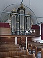 Interieur, aanzicht orgel, orgelnummer 1071 - Nijeholtpade - 20417332 - RCE.jpg 884 × 1,200; 173 KB
-
 Nijeholtpade 17-4-2008 14-46-10.jpg 2,560 × 1,920; 1.9 MB
.jpg)
.jpg)
.jpg)


