Category:Nieuw-Loosdrechtsedijk 42, Nieuw-Loosdrecht
Jump to navigation
Jump to search
| Object location | | View all coordinates using: OpenStreetMap |
|---|
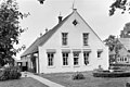
farmhouse in Wijdemeren, Netherlands  | |||||
| Upload media | |||||
| Instance of | |||||
|---|---|---|---|---|---|
| Location | Loosdrecht, Wijdemeren, North Holland, Netherlands | ||||
| Street address |
| ||||
| Heritage designation |
| ||||
 | |||||
|
This is a category about rijksmonument number 26191
|
| Address |
|
Media in category "Nieuw-Loosdrechtsedijk 42, Nieuw-Loosdrecht"
The following 5 files are in this category, out of 5 total.
-
 Nieuw Loosdrecht - Hilverzicht RM26191.JPG 4,509 × 2,860; 1.08 MB
-
 Overzicht - Nieuw-Loosdrecht - 20165497 - RCE.jpg 1,200 × 803; 266 KB
-
 Voor- en zijgevel nr. FU 4; RDMZ, Zeist - Nieuw-Loosdrecht - 20466644 - RCE.jpg 1,200 × 900; 176 KB
-
 Vooraanzicht - Nieuw-Loosdrecht - 20165498 - RCE.jpg 1,200 × 801; 210 KB
-
 Zij- en voorgevel nr. FU 5; RDMZ, Zeist - Nieuw-Loosdrecht - 20466643 - RCE.jpg 1,200 × 900; 204 KB


