Category:Nilfanion/EA
Jump to navigation
Jump to search

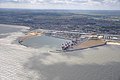
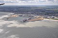
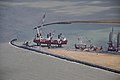
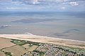
This temporary user category contains aerial photography of the United Kingdom, from the Environment Agency which is licensed under the OGL. There are two main types of images:
- Coastal surveys
- Incident response surveys (ie flooding)
- Sample images
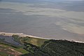
-
 Looe, Cornwall
 -
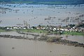 Flooding on the Somerset Levels
 -
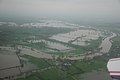 Flooding in the Severn valley
 -
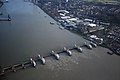 Thames Barrier raised
 -
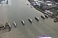 Thames Barrier lowered


All files are geocoded, providing the camera location. This information cannot be reliably converted automatically to subject categories, as the distance between the plane and the area photographed is substantial manual intervention is required. I will be working through applying the correct location categories. Help welcome.
Media in category "Nilfanion/EA"
The following 200 files are in this category, out of 1,512 total.
(previous page) (next page)-
 2011-08-11 Coastline of the parish of Overstrand, Norfolk.jpg 4,288 × 2,848; 4.87 MB
-
 2011-08-11 Coastline of the parish of Sidestrand, Norfolk.jpg 4,288 × 2,848; 4.4 MB
-
 2011-08-11 East end of the village of Overstrand, Norfolk.jpg 4,288 × 2,848; 5.24 MB
-
 Environment Agency 110809 130730.jpg 4,288 × 2,848; 4.31 MB
-
 Environment Agency 110809 130743.jpg 4,288 × 2,848; 4.34 MB
-
 Environment Agency 110809 130749.jpg 4,288 × 2,848; 4.83 MB
-
 Environment Agency 110809 130755.jpg 4,288 × 2,848; 4.9 MB
-
 Environment Agency 110809 130803a.jpg 4,288 × 2,848; 5.02 MB
-
 Environment Agency 110809 130810.jpg 4,288 × 2,848; 5.31 MB
-
 Environment Agency 110809 130819.jpg 4,288 × 2,848; 5.13 MB
-
 Environment Agency 110809 130829.jpg 4,288 × 2,848; 4.84 MB
-
 Environment Agency 110809 130834.jpg 4,288 × 2,848; 4.24 MB
-
 Environment Agency 110809 130849.jpg 4,288 × 2,848; 4.35 MB
-
 Environment Agency 110809 130859.jpg 4,288 × 2,848; 5.31 MB
-
 Environment Agency 110809 130907.jpg 4,288 × 2,848; 4.92 MB
-
 Environment Agency 110809 130944a.jpg 4,288 × 2,848; 4.55 MB
-
 Environment Agency 110809 130948a.jpg 4,288 × 2,848; 4.82 MB
-
 Environment Agency 110809 130954a.jpg 4,288 × 2,848; 4.8 MB
-
 Environment Agency 110809 131000.jpg 4,288 × 2,848; 4.74 MB
-
 Environment Agency 110809 131004.jpg 4,288 × 2,848; 5.16 MB
-
 Environment Agency 110809 131010a.jpg 4,288 × 2,848; 4.41 MB
-
 Environment Agency 110809 131014.jpg 4,288 × 2,848; 4.71 MB
-
 Environment Agency 110809 131026.jpg 4,288 × 2,848; 4.64 MB
-
 Environment Agency 110809 131034.jpg 4,288 × 2,848; 4.56 MB
-
 Environment Agency 110809 131039a.jpg 4,288 × 2,848; 4.8 MB
-
 Environment Agency 110809 131043.jpg 4,288 × 2,848; 4.59 MB
-
 Environment Agency 110809 131049a.jpg 4,288 × 2,848; 4.48 MB
-
 Environment Agency 110809 131055.jpg 4,288 × 2,848; 4.33 MB
-
 Environment Agency 110809 131058.jpg 4,288 × 2,848; 4.24 MB
-
 Environment Agency 110809 131105.jpg 4,288 × 2,848; 4.61 MB
-
 Environment Agency 110809 131110.jpg 4,288 × 2,848; 4.15 MB
-
 Environment Agency 110809 131124.jpg 4,288 × 2,848; 4.36 MB
-
 Environment Agency 110809 131516.jpg 4,288 × 2,848; 4.2 MB
-
 Environment Agency 110809 131526.jpg 4,288 × 2,848; 4.11 MB
-
 Environment Agency 110809 131537.jpg 4,288 × 2,848; 4.73 MB
-
 Environment Agency 110809 131544.jpg 4,288 × 2,848; 5.51 MB
-
 Environment Agency 110809 131547.jpg 4,288 × 2,848; 5.63 MB
-
 Environment Agency 110809 131551.jpg 4,288 × 2,848; 4.81 MB
-
 Environment Agency 110809 131555.jpg 4,288 × 2,848; 4.72 MB
-
 Environment Agency 110809 131559.jpg 4,288 × 2,848; 4.89 MB
-
 Environment Agency 110809 131604.jpg 4,288 × 2,848; 5.1 MB
-
 Environment Agency 110809 131609.jpg 4,288 × 2,848; 5.1 MB
-
 Environment Agency 110809 131614.jpg 4,288 × 2,848; 5.39 MB
-
 Environment Agency 110809 131618.jpg 4,288 × 2,848; 4.72 MB
-
 Environment Agency 110809 131622a.jpg 4,288 × 2,848; 5.01 MB
-
 Environment Agency 110809 131626.jpg 4,288 × 2,848; 4.45 MB
-
 Environment Agency 110809 131631.jpg 4,288 × 2,848; 4.28 MB
-
 Environment Agency 110809 131638.jpg 4,288 × 2,848; 4.65 MB
-
 Environment Agency 110809 131645.jpg 4,288 × 2,848; 4.27 MB
-
 Environment Agency 110809 131649.jpg 4,288 × 2,848; 3.99 MB
-
 Environment Agency 110809 131653a.jpg 4,288 × 2,848; 5.16 MB
-
 Environment Agency 110809 131656a.jpg 4,288 × 2,848; 5.08 MB
-
 Environment Agency 110809 131704.jpg 4,288 × 2,848; 4.44 MB
-
 Environment Agency 110809 131709.jpg 4,288 × 2,848; 4.1 MB
-
 Environment Agency 110809 131712.jpg 4,288 × 2,848; 4.57 MB
-
 Environment Agency 110809 131716.jpg 4,288 × 2,848; 4.2 MB
-
 Environment Agency 110809 131722.jpg 4,288 × 2,848; 4.21 MB
-
 Environment Agency 110809 131727.jpg 4,288 × 2,848; 4.21 MB
-
 Environment Agency 110809 131731.jpg 4,288 × 2,848; 5.02 MB
-
 Environment Agency 110809 131736.jpg 4,288 × 2,848; 5.29 MB
-
 Environment Agency 110809 131742a.jpg 4,288 × 2,848; 4.49 MB
-
 Environment Agency 110809 131748.jpg 4,288 × 2,848; 4.53 MB
-
 Environment Agency 110809 131755.jpg 4,288 × 2,848; 4.49 MB
-
 Environment Agency 110809 131758.jpg 4,288 × 2,848; 4.68 MB
-
 Environment Agency 110809 131803.jpg 4,288 × 2,848; 4.85 MB
-
 Environment Agency 110809 131810.jpg 4,288 × 2,848; 4.31 MB
-
 Environment Agency 110809 131847.jpg 4,288 × 2,848; 5.93 MB
-
 Environment Agency 110809 131856a.jpg 4,288 × 2,848; 5.58 MB
-
 Environment Agency 110809 131904.jpg 4,288 × 2,848; 5.84 MB
-
 Environment Agency 110809 131912.jpg 4,288 × 2,848; 5.72 MB
-
 Environment Agency 110809 131919.jpg 4,288 × 2,848; 6.16 MB
-
 Environment Agency 110809 131925.jpg 4,288 × 2,848; 5.95 MB
-
 Environment Agency 110809 131932.jpg 4,288 × 2,848; 5.03 MB
-
 Environment Agency 110809 131942a.jpg 4,288 × 2,848; 5.11 MB
-
 Environment Agency 110809 131950.jpg 4,288 × 2,848; 6.44 MB
-
 Environment Agency 110809 131952.jpg 4,288 × 2,848; 5.52 MB
-
 Environment Agency 110809 131955.jpg 4,288 × 2,848; 6.03 MB
-
 Environment Agency 110809 131958.jpg 4,288 × 2,848; 5.75 MB
-
 Environment Agency 110809 132003.jpg 4,288 × 2,848; 6.49 MB
-
 Environment Agency 110809 132012.jpg 4,288 × 2,848; 5.31 MB
-
 Environment Agency 110809 132017.jpg 4,288 × 2,848; 5.2 MB
-
 Environment Agency 110809 132021.jpg 4,288 × 2,848; 5.83 MB
-
 Environment Agency 110809 132029.jpg 4,288 × 2,848; 5.7 MB
-
 Environment Agency 110809 132036.jpg 4,288 × 2,848; 4.75 MB
-
 Environment Agency 110809 132042a.jpg 4,288 × 2,848; 4.92 MB
-
 Environment Agency 110809 132050.jpg 4,288 × 2,848; 5.11 MB
-
 Environment Agency 110809 132054.jpg 4,288 × 2,848; 5.14 MB
-
 Environment Agency 110809 132058.jpg 4,288 × 2,848; 5.11 MB
-
 Environment Agency 110809 132105.jpg 4,288 × 2,848; 5.04 MB
-
 Environment Agency 110809 132112.jpg 4,288 × 2,848; 5.46 MB
-
 Environment Agency 110809 132117.jpg 4,288 × 2,848; 5.11 MB
-
 Environment Agency 110809 132125.jpg 4,288 × 2,848; 5.78 MB
-
 Environment Agency 110809 132131.jpg 4,288 × 2,848; 5.69 MB
-
 Environment Agency 110809 132134.jpg 4,288 × 2,848; 5.44 MB
-
 Environment Agency 110809 132142a.jpg 4,288 × 2,848; 6 MB
-
 Environment Agency 110809 132146.jpg 4,288 × 2,848; 5.9 MB
-
 Environment Agency 110809 132149.jpg 4,288 × 2,848; 5.8 MB
-
 Environment Agency 110809 132152.jpg 4,288 × 2,848; 4.69 MB
-
 Environment Agency 110809 132158a.jpg 4,288 × 2,848; 5.87 MB
-
 Environment Agency 110809 132203.jpg 4,288 × 2,848; 5.82 MB
-
 Environment Agency 110809 132207.jpg 4,288 × 2,848; 5.79 MB
-
 Environment Agency 110809 132211.jpg 4,288 × 2,848; 5.32 MB
-
 Environment Agency 110809 132214.jpg 4,288 × 2,848; 4.71 MB
-
 Environment Agency 110809 132218.jpg 4,288 × 2,848; 4.37 MB
-
 Environment Agency 110809 132221.jpg 4,288 × 2,848; 4.61 MB
-
 Environment Agency 110809 132224.jpg 4,288 × 2,848; 4.63 MB
-
 Environment Agency 110809 132228.jpg 4,288 × 2,848; 4.8 MB
-
 Environment Agency 110809 132232.jpg 4,288 × 2,848; 4.36 MB
-
 Environment Agency 110809 132241.jpg 4,288 × 2,848; 4.85 MB
-
 Environment Agency 110809 132938.jpg 4,288 × 2,848; 3.92 MB
-
 Environment Agency 110809 132944.jpg 4,288 × 2,848; 4.75 MB
-
 Environment Agency 110809 132950.jpg 4,288 × 2,848; 4.69 MB
-
 Environment Agency 110809 132957.jpg 4,288 × 2,848; 4.68 MB
-
 Environment Agency 110809 133004.jpg 4,288 × 2,848; 4.7 MB
-
 Environment Agency 110809 133011.jpg 4,288 × 2,848; 4.56 MB
-
 Environment Agency 110809 133016.jpg 4,288 × 2,848; 4.45 MB
-
 Environment Agency 110809 133024.jpg 4,288 × 2,848; 5.66 MB
-
 Environment Agency 110809 133031.jpg 4,288 × 2,848; 5.21 MB
-
 Environment Agency 110809 133038.jpg 4,288 × 2,848; 4.69 MB
-
 Environment Agency 110809 133043.jpg 4,288 × 2,848; 4.79 MB
-
 Environment Agency 110809 133048.jpg 4,288 × 2,848; 4.51 MB
-
 Environment Agency 110809 133052.jpg 4,288 × 2,848; 4.72 MB
-
 Environment Agency 110809 133056.jpg 4,288 × 2,848; 5.34 MB
-
 Environment Agency 110809 133102.jpg 4,288 × 2,848; 5.28 MB
-
 Environment Agency 110809 133107.jpg 4,288 × 2,848; 4.66 MB
-
 Environment Agency 110809 133111.jpg 4,288 × 2,848; 4.66 MB
-
 Environment Agency 110809 133116.jpg 4,288 × 2,848; 4.49 MB
-
 Environment Agency 110809 133124.jpg 4,288 × 2,848; 5.35 MB
-
 Environment Agency 110809 133129.jpg 4,288 × 2,848; 4.76 MB
-
 Environment Agency 110809 133133.jpg 4,288 × 2,848; 5.31 MB
-
 Environment Agency 110809 133138.jpg 4,288 × 2,848; 5.31 MB
-
 Environment Agency 110809 133144.jpg 4,288 × 2,848; 4.74 MB
-
 Environment Agency 110809 133150.jpg 4,288 × 2,848; 5.64 MB
-
 Environment Agency 110809 133201.jpg 4,288 × 2,848; 5.88 MB
-
 Environment Agency 110809 133208.jpg 4,288 × 2,848; 5.79 MB
-
 Environment Agency 110809 133214a.jpg 4,288 × 2,848; 5.56 MB
-
 Environment Agency 110809 133223a.jpg 4,288 × 2,848; 6.05 MB
-
 Environment Agency 110809 133230.jpg 4,288 × 2,848; 5.82 MB
-
 Environment Agency 110809 133234.jpg 4,288 × 2,848; 5.9 MB
-
 Environment Agency 110809 133239a.jpg 4,288 × 2,848; 5.77 MB
-
 Environment Agency 110809 133242.jpg 4,288 × 2,848; 5.33 MB
-
 Environment Agency 110809 133244.jpg 4,288 × 2,848; 5.49 MB
-
 Environment Agency 110809 133248.jpg 4,288 × 2,848; 5.84 MB
-
 Environment Agency 110809 133255.jpg 4,288 × 2,848; 6.14 MB
-
 Environment Agency 110809 133301.jpg 4,288 × 2,848; 6.22 MB
-
 Environment Agency 110809 133307.jpg 4,288 × 2,848; 6.12 MB
-
 Environment Agency 110809 133313.jpg 4,288 × 2,848; 5.5 MB
-
 Environment Agency 110809 133335.jpg 4,288 × 2,848; 5.47 MB
-
 Environment Agency 110809 133347.jpg 4,288 × 2,848; 4.84 MB
-
 Environment Agency 110809 133352.jpg 4,288 × 2,848; 5.23 MB
-
 Environment Agency 110809 133400.jpg 4,288 × 2,848; 5.21 MB
-
 Environment Agency 110809 133402a.jpg 4,288 × 2,848; 5.41 MB
-
 Environment Agency 110809 133407.jpg 4,288 × 2,848; 5.3 MB
-
 Environment Agency 110809 133412.jpg 4,288 × 2,848; 4.48 MB
-
 Environment Agency 110809 133418.jpg 4,288 × 2,848; 5.71 MB
-
 Environment Agency 110809 133422.jpg 4,288 × 2,848; 5.91 MB
-
 Environment Agency 110809 133426.jpg 4,288 × 2,848; 5.92 MB
-
 Environment Agency 110809 133429a.jpg 4,288 × 2,848; 5.73 MB
-
 Environment Agency 110809 133432a.jpg 4,288 × 2,848; 5.51 MB
-
 Environment Agency 110809 133441a.jpg 4,288 × 2,848; 5.77 MB
-
 Environment Agency 110809 133445.jpg 4,288 × 2,848; 6.23 MB
-
 Environment Agency 110809 133448.jpg 4,288 × 2,848; 5.85 MB
-
 Environment Agency 110809 133453.jpg 4,288 × 2,848; 5.85 MB
-
 Environment Agency 110809 133457a.jpg 4,288 × 2,848; 5.81 MB
-
 Environment Agency 110809 133459.jpg 4,288 × 2,848; 5.41 MB
-
 Environment Agency 110809 133511.jpg 4,288 × 2,848; 4.78 MB
-
 Environment Agency 110809 133513.jpg 4,288 × 2,848; 4.79 MB
-
 Environment Agency 110809 133516.jpg 4,288 × 2,848; 4.65 MB
-
 Environment Agency 110809 133519.jpg 4,288 × 2,848; 4.67 MB
-
 Environment Agency 110809 133526.jpg 4,288 × 2,848; 4.23 MB
-
 Environment Agency 110809 133531.jpg 4,288 × 2,848; 4.82 MB
-
 Environment Agency 110809 133538.jpg 4,288 × 2,848; 4.87 MB
-
 Environment Agency 110809 133941.jpg 4,288 × 2,848; 4.18 MB
-
 Environment Agency 110809 133951.jpg 4,288 × 2,848; 4.64 MB
-
 Environment Agency 110809 134000.jpg 4,288 × 2,848; 4.27 MB
-
 Environment Agency 110809 134006.jpg 4,288 × 2,848; 3.6 MB
-
 Environment Agency 110809 134011a.jpg 4,288 × 2,848; 4.44 MB
-
 Environment Agency 110809 134014.jpg 4,288 × 2,848; 3.97 MB
-
 Environment Agency 110809 134019a.jpg 4,288 × 2,848; 4.85 MB
-
 Environment Agency 110809 134023.jpg 4,288 × 2,848; 4.63 MB
-
 Environment Agency 110809 134027.jpg 4,288 × 2,848; 4.84 MB
-
 Environment Agency 110809 134031a.jpg 4,288 × 2,848; 4.85 MB
-
 Environment Agency 110809 134035a.jpg 4,288 × 2,848; 4.54 MB
-
 Environment Agency 110809 134042.jpg 4,288 × 2,848; 4.46 MB
-
 Environment Agency 110809 134044.jpg 4,288 × 2,848; 5.26 MB
-
 Environment Agency 110809 134047.jpg 4,288 × 2,848; 4.58 MB
-
 Environment Agency 110809 134051.jpg 4,288 × 2,848; 3.96 MB
-
 Environment Agency 110809 134113.jpg 4,288 × 2,848; 4.06 MB
-
 Environment Agency 110809 134118a.jpg 4,288 × 2,848; 4.02 MB
-
 Environment Agency 110809 134126.jpg 4,288 × 2,848; 4.54 MB
-
 Environment Agency 110809 134134.jpg 4,288 × 2,848; 4.83 MB
-
 Environment Agency 110809 134141.jpg 4,288 × 2,848; 4.86 MB
-
 Environment Agency 110809 134145.jpg 4,288 × 2,848; 4.16 MB
-
 Environment Agency 110809 134149.jpg 4,288 × 2,848; 4.78 MB
-
 Environment Agency 110809 134154.jpg 4,288 × 2,848; 5.18 MB
-
 Environment Agency 110809 134159.jpg 4,288 × 2,848; 4.76 MB
-
 Environment Agency 110809 134203.jpg 4,288 × 2,848; 4.67 MB
-
 Environment Agency 110809 134207.jpg 4,288 × 2,848; 4.52 MB
-
 Environment Agency 110809 134212.jpg 4,288 × 2,848; 4.7 MB
-
 Environment Agency 110809 134217a.jpg 4,288 × 2,848; 4.5 MB


