Category:Nimmitabel, New South Wales
Jump to navigation
Jump to search
town in New South Wales, Australia .jpg) | |||||
| Upload media | |||||
| Instance of | |||||
|---|---|---|---|---|---|
| Location |
| ||||
| Population |
| ||||
| Elevation above sea level |
| ||||
 | |||||
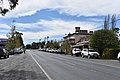
English: Nimmitabel ( postcode: 2631) is a small town in the Monaro region in southeast New South Wales, Australia, in the Cooma-Monaro Shire local government area. At the 2006 census, Nimmitabel had a population of 237 people.
Français : Nimmitabel ( habitants) est une localité de Nouvelle-Galles du Sud, en Australie à 152 km au sud de Canberra et à 37 km au sud de Cooma sur la Monaro Highway qui est fusionnée dans la région avec la Snowy Mountains Highway.
Subcategories
This category has the following 4 subcategories, out of 4 total.
Media in category "Nimmitabel, New South Wales"
The following 18 files are in this category, out of 18 total.
-
 Elephant at the Nimmitabel Bakery, NSW, Australia, 2023, 01.jpg 4,032 × 3,024; 6.13 MB
-
 Elephant at the Nimmitabel Bakery, NSW, Australia, 2023, 02.jpg 3,599 × 2,990; 5.41 MB
-
 Elephant at the Nimmitabel Bakery, NSW, Australia, 2023, 03.jpg 2,731 × 3,472; 4.61 MB
-
 Elephant Bakery Nimmitabel.JPG 4,000 × 3,000; 1.74 MB
-
 Monaro Highway in Nimmitabel.jpg 2,048 × 1,536; 580 KB
-
 Nimmitabel - panoramio (1).jpg 2,700 × 1,800; 1.49 MB
-
 Nimmitabel - panoramio (2).jpg 2,700 × 1,800; 799 KB
-
 Nimmitabel - panoramio (3).jpg 2,700 × 1,800; 1.13 MB
-
 Nimmitabel - panoramio (4).jpg 2,700 × 1,800; 780 KB
-
 Nimmitabel - panoramio (5).jpg 2,700 × 1,800; 884 KB
-
 Nimmitabel - panoramio (7).jpg 2,700 × 1,800; 970 KB
-
 Nimmitabel - panoramio (9).jpg 2,700 × 1,800; 984 KB
-
 Nimmitabel - panoramio.jpg 2,700 × 1,800; 1.7 MB
-
 Nimmitabel banner.jpg 3,576 × 511; 585 KB
-
 Nimmitabel Bombala St 001.JPG 6,000 × 4,000; 11.8 MB
-
 Royal Arms B&B, Nimmitabel, NSW, 2023, 01.jpg 3,576 × 2,664; 2.89 MB
-
 Royal Arms B&B, Nimmitabel, NSW, 2023, 02.jpg 2,909 × 2,423; 2.63 MB
-
 Royal Arms B&B, Nimmitabel, NSW, 2023, 03.jpg 3,917 × 2,416; 3.3 MB


.jpg)
.jpg)
.jpg)
.jpg)
.jpg)
.jpg)


