Category:Notre-Dame-des-Marches, Broc
Jump to navigation
Jump to search
| Object location | | View all coordinates using: OpenStreetMap |
|---|
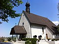
chapel building in Broc in the canton of Fribourg, Switzerland  | |||||
| Upload media | |||||
| Instance of | |||||
|---|---|---|---|---|---|
| Part of | |||||
| Location | Broc, Gruyère District, Canton of Fribourg, Switzerland | ||||
| Street address |
| ||||
| Diocese | |||||
| Heritage designation | |||||
| Inception |
| ||||
| Religion or worldview | |||||
| official website | |||||
 | |||||
Media in category "Notre-Dame-des-Marches, Broc"
The following 3 files are in this category, out of 3 total.
-
 ND des marches face.jpg 1,936 × 2,592; 1.87 MB
-
 ND des marches full.jpg 2,592 × 1,936; 2.25 MB
-
 Notre Dame des Marches Jul 2011.jpg 3,168 × 4,752; 5.81 MB

