Category:Nutscale Reservoir
Jump to navigation
Jump to search
reservoir in Somerset, England, UK | |||||
| Upload media | |||||
| Instance of | |||||
|---|---|---|---|---|---|
| Location | Luccombe, Somerset West and Taunton, Somerset, South West England, England | ||||
| Elevation above sea level |
| ||||
 | |||||
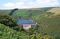
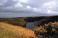
Nutscale Reservoir is a reservoir located in Exmoor in north west Somerset, England. It supplies the town of Minehead and nearby Porlock and Porlock Weir.[1] The reservoir is part of the River Horner catchment area, and is dammed. Nutscale Reservoir is fed by Nutscale Water and water is piped to the Porlock Treatment Works, supplying around 3,000 cubic metres (110,000 cu ft) per day, and to six other farms and camp sites. It was built in 1942, and typically provides good quality water, although high levels of geosmin were recorded in 2008.[2] The fishing rights to the reservoir are owned by the National Trust, as part of its Holnicote Estate, and leased out privately.
Media in category "Nutscale Reservoir"
The following 12 files are in this category, out of 12 total.
-
 Dam, at Nutscale Reservoir (geograph 3429608).jpg 768 × 1,024; 263 KB
-
 Luccombe, Nutscale Reservoir - geograph.org.uk - 216940.jpg 640 × 424; 224 KB
-
 Nutscale Reservoir (geograph 3245351).jpg 1,600 × 1,200; 637 KB
-
 Nutscale Reservoir - geograph.org.uk - 213817.jpg 640 × 418; 92 KB
-
 Nutscale Reservoir - geograph.org.uk - 3428161.jpg 1,024 × 768; 205 KB
-
 Nutscale Reservoir - geograph.org.uk - 3429667.jpg 1,024 × 768; 224 KB
-
 Nutscale Reservoir - geograph.org.uk - 669028.jpg 640 × 417; 86 KB
-
 Nutscale Water, below the reservoir dam (geograph 3429621).jpg 1,024 × 768; 238 KB
-
 View of Nutscale reservoir - geograph.org.uk - 2788731.jpg 640 × 451; 194 KB
-
 Water Buttercups, Nutscale Reservoir - geograph.org.uk - 3429697.jpg 1,024 × 768; 245 KB
-
 Water control point, Nutscale reservoir - geograph.org.uk - 3429709.jpg 1,024 × 768; 313 KB
-
 Waters edge, Nutscale Reservoir (geograph 3429633).jpg 1,024 × 768; 304 KB
.jpg)

.jpg)


.jpg)


.jpg)