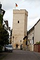
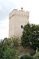
Category:Obertorturm (Niederbrechen)
Jump to navigation
Jump to search
| Object location | | View all coordinates using: OpenStreetMap |
|---|
tower in Niederbrechen  | |||||
| Upload media | |||||
| Instance of | |||||
|---|---|---|---|---|---|
| Location | Niederbrechen, Brechen, Limburg-Weilburg, Giessen Government Region, Hesse, Germany | ||||
| Street address |
| ||||
| Heritage designation | |||||
 | |||||
This is the category of the Hessian Kulturdenkmal (cultural monument) with the ID 50905 (Wikidata)
|
Media in category "Obertorturm (Niederbrechen)"
The following 10 files are in this category, out of 10 total.
-
 Gefangenenturm Niederbrechen.JPG 4,000 × 3,000; 4.43 MB
-
 Luthmer III-157-Niederbrechen Mauerturm.jpg 1,127 × 1,503; 1.06 MB
-
 Niederbrechen Gefangenenturm.jpg 2,080 × 3,404; 627 KB
-
 Obertorturm Niederbrechen 01.jpg 3,456 × 5,184; 9 MB
-
 Obertorturm Niederbrechen 02.jpg 5,184 × 3,456; 6.68 MB
-
 Obertorturm Niederbrechen 03.jpg 3,456 × 5,184; 8.44 MB
-
 Obertorturm Niederbrechen 04.jpg 3,456 × 5,184; 8.54 MB
-
 Obertorturm Niederbrechen detail 01.jpg 3,456 × 5,184; 11.29 MB
-
 Obertorturm Niederbrechen Tafel.jpg 5,184 × 3,456; 11.31 MB
-
 ObertorturmNiederbrechen.jpg 2,266 × 2,302; 678 KB


