Category:Ohorn
Jump to navigation
Jump to search
municipality of Germany    | |||||
| Upload media | |||||
| Instance of |
| ||||
|---|---|---|---|---|---|
| Location | Bautzen District, Saxony, Germany | ||||
| Population |
| ||||
| Area |
| ||||
| Elevation above sea level |
| ||||
| official website | |||||
 | |||||
Urban municipalities:
Bautzen · Bischofswerda · Hoyerswerda · Kamenz · Radeberg · Bernsdorf · Elstra · Großröhrsdorf · Königsbrück · Lauta · Pulsnitz · Schirgiswalde-Kirschau · Weißenberg · Wilthen · Wittichenau
Rural municipalities:
Arnsdorf · Burkau · Crostwitz · Cunewalde · Demitz-Thumitz · Doberschau-Gaußig · Elsterheide · Frankenthal · Großdubrau · Großharthau · Großnaundorf · Großpostwitz · Göda · Haselbachtal · Hochkirch · Kubschütz · Königswartha · Laußnitz · Lichtenberg · Lohsa · Malschwitz · Nebelschütz · Neschwitz · Neukirch · Neukirch/Lausitz · Obergurig · Ohorn · Ottendorf-Okrilla · Oßling · Panschwitz-Kuckau · Puschwitz · Radibor · Ralbitz-Rosenthal · Rammenau · Räckelwitz · Schmölln-Putzkau · Schwepnitz · Sohland an der Spree · Spreetal · Steina · Steinigtwolmsdorf · Wachau
Former municipalities:
Subcategories
This category has the following 10 subcategories, out of 10 total.
G
- Gickelsberg (Ohorn) (8 F)
N
- Natural monuments in Ohorn (empty)
P
S
- Schleißberg (Ohorn) (6 F)
- Sealing stamps of Ohorn (2 F)
- Stone signposts in Ohorn (1 F)
Media in category "Ohorn"
The following 10 files are in this category, out of 10 total.
-
 2012-02 BAB-4 1.jpg 1,444 × 963; 1.56 MB
-
 2012-02 BAB-4 2.jpg 1,444 × 963; 1.56 MB
-
 Kirchlehn in Ohorn.jpg 6,000 × 4,000; 2.68 MB
-
 Meilenblatt B 287 Rammenau.jpg 9,030 × 9,030; 35.73 MB
-
 Ohorn in BZ.png 590 × 551; 26 KB
-
 Ohorn Luchsenburg.jpg 3,968 × 2,976; 4.13 MB
-
 Ohorn-Hochsteinstraße-1.jpg 2,438 × 3,529; 2.48 MB
-
 Ohorn-Hochsteinstraße-2.jpg 2,172 × 2,896; 1.95 MB
-
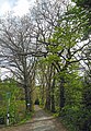
 Waldstraße 2a ohorn 2020-05-16 .jpg 3,648 × 2,736; 4.59 MB
-
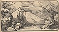 Was die Heimat erzählt (Störzner) 297a.jpg 812 × 442; 162 KB


_297a.jpg)