Category:Old City Hall, Boston
Zur Navigation springen
Zur Suche springen
| Objektposition | | Karte mit allen Koordinaten: OpenStreetMap |
|---|
Altes Rathaus von Boston .jpg) | |||||
| Medium hochladen | |||||
| Ist ein(e) |
| ||||
|---|---|---|---|---|---|
| Ort | Massachusetts | ||||
| Straße | |||||
| Architekturstil |
| ||||
| Architekt | |||||
| Schutzkategorie |
| ||||
 | |||||
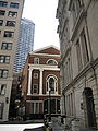
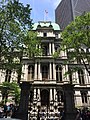
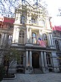
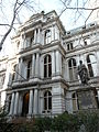
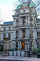
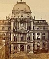
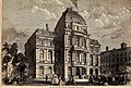
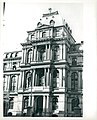
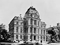
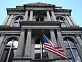
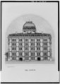
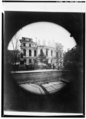
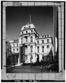
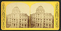
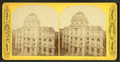
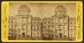
English: Boston's Old City Hall, built at 45 School Street from 1862 to 1865, was Boston's third city hall, replacing the previous "Old City Hall" built in 1810 as a courthouse. Old City Hall was home to the city council from 1865 to 1969, and was converted to an office building after the Boston government moved to the current city hall. Old City Hall was one of the first buildings in the French Second Empire style to be built in the United States. The building's architects were Gridley James Fox Bryant and Arthur Gilman. It was designated a National Historic Landmark in 1970.
|
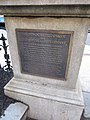
Diese Kategorie enthält Dateien zu einem Objekt, das im National Register of Historic Places der Vereinigten Staaten verzeichnet ist. Die Referenznummer lautet 70000687. |
Unterkategorien
Es werden 4 von insgesamt 4 Unterkategorien in dieser Kategorie angezeigt:
In Klammern die Anzahl der enthaltenen Kategorien (K), Seiten (S), Dateien (D)
Medien in der Kategorie „Old City Hall, Boston“
Folgende 115 Dateien sind in dieser Kategorie, von 115 insgesamt.
-
 1910 CityHall Boston.png 667 × 499; 295 KB
-
 1930 CityHall Boston byLeonAbdalian 2589547441.jpg 934 × 1.200; 222 KB
-
 2010 OldCityHall PiAlley CityHallAve Boston 4.jpg 2.736 × 3.648; 4,21 MB
-
 2017 Old City Hall, 45 School Street, Boston, Massachusetts.jpg 4.608 × 3.456; 4,22 MB
-
 20180526 - 31 - Boston, MA (Downtown Crossing).jpg 1.500 × 2.000; 846 KB
-
 20180526 - 32 - Boston, MA (Downtown Crossing).jpg 1.470 × 1.960; 605 KB
-
 Boston (2019) - 013.jpg 3.000 × 4.000; 2,39 MB
-
 Boston (2019) - 019.jpg 4.000 × 3.000; 3,3 MB
-
 Boston (2019) - 020.jpg 3.000 × 4.000; 3,45 MB
-
 Boston (2019) - 021.jpg 3.000 × 4.000; 2,8 MB
-
 Boston (2019) - 022.jpg 4.000 × 3.000; 2,92 MB
-
 Boston Old City Hall.JPG 1.920 × 2.560; 1,98 MB
-
 Boston's Old City Hall (32852355338).jpg 5.064 × 3.376; 10,7 MB
-
 Boston, Massachusetts (50912818917).jpg 2.581 × 3.872; 6,37 MB
-
 BostonOCH.JPG 345 × 415; 70 KB
-
 BostonOldCityHall.jpg 895 × 971; 154 KB
-
 BostonOldCityHall.JPG 1.536 × 2.048; 1,11 MB
-
 City Hall on School Street (12440074074).jpg 4.123 × 4.938; 2,08 MB
-
 City Hall, School Street - DPLA - 6c570e52f090387489be46f5413a11b7.jpg 608 × 800; 177 KB
-
 Harper's weekly (1865) (14578749118).jpg 2.996 × 2.016; 1,66 MB
-
 Home for the elderly, Pond St., Jamaica Plain (13561213863).jpg 6.046 × 4.892; 3,16 MB
-
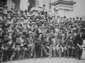
 James Michael Curley holding a press conference at Boston City Hall in 1913.jpg 16.657 × 12.487; 8,39 MB
-
-
 Mayor John F. Collins holds a trophy with two unidentified men (13911288323).jpg 6.031 × 4.908; 2,34 MB
-
 Mayor John F. Collins with a group of unidentified men (12773717244).jpg 6.031 × 4.892; 2,94 MB
-
 Men of government at Boston City Hall in 1910.jpg 15.700 × 11.726; 10,89 MB
-

-
 City hall (NYPL b11707562-G90F309 005F).tiff 3.072 × 1.663; 14,62 MB
-
 City hall, Boston, Mass (NYPL b11707578-G90F343 029F).tiff 3.072 × 1.568; 13,78 MB
-
 City hall, Boston, Mass (NYPL b11707578-G90F343 029B).tiff 3.072 × 1.573; 13,83 MB
-
 Old City Hall (9502553459).jpg 4.823 × 5.943; 2,08 MB
-
 Old City Hall (Boston).jpg 535 × 398; 47 KB
-
 Old City Hall - Boston, MA.jpg 900 × 1.600; 256 KB
-
 Old city hall boston front.JPG 800 × 1.066; 218 KB
-
 Old City Hall Boston small copy.jpg 1.500 × 766; 1,67 MB
-
 Old city hall boston up.JPG 1.024 × 768; 219 KB
-
 Old city hall k.jpg 3.406 × 2.259; 1,02 MB
-
 Old City Hall, Boston (10695740866).jpg 5.846 × 4.692; 2,61 MB
-
 Old City Hall, Boston (23797497845).jpg 5.760 × 3.840; 21 MB
-
 Old City Hall, Boston (493551) (11061696346).jpg 3.154 × 2.103; 2,03 MB
-
 Old City Hall, Boston, MA - front facade.JPG 3.264 × 2.448; 3,78 MB
-
 Old City Hall, School Street (13105933983).jpg 6.015 × 4.877; 3,12 MB
-
 Old City Hall, Vertical View of Facade.jpg 3.632 × 5.456; 3,62 MB
-
 Old-city-hall-01.jpg 500 × 375; 136 KB
-
 Photo inside a Boston City Council office in 1910.jpg 17.822 × 13.389; 9,28 MB
-

-

-
-

-
-

-
-

-

-

-
-

-

-
 Three unidentified men with Mayor John F. Collins (10926313536).jpg 5.831 × 4.680; 2,04 MB
-
 Three unidentified women and two men with Mayor John F. Collins (13911373534).jpg 6.031 × 4.923; 1,83 MB
-
 TV Weather girls present Mayor John F. Collins with a weather instrument (12775978223).jpg 6.015 × 4.892; 2,12 MB
-
 Unidentified man and woman and Mayor John F. Collins (11071847316).jpg 5.877 × 4.708; 2,37 MB
-
 Unidentified officers (10926197415).jpg 5.769 × 4.523; 2,9 MB
-
 USA-Benjamin Franklin Statue0.jpg 3.417 × 5.136; 13,29 MB
-

-
 City hall, Boston, from Robert N. Dennis collection of stereoscopic views 2.jpg 2.737 × 1.415; 1,41 MB
-
 City hall, Boston, from Robert N. Dennis collection of stereoscopic views 2.png 2.737 × 1.415; 4,68 MB
-
 City hall, Boston, from Robert N. Dennis collection of stereoscopic views 3.jpg 2.737 × 1.400; 1,41 MB
-
 City hall, Boston, from Robert N. Dennis collection of stereoscopic views 3.png 2.737 × 1.400; 4,57 MB
-
 City hall, Boston, from Robert N. Dennis collection of stereoscopic views 4.jpg 2.737 × 1.423; 1,47 MB
-
 City hall, Boston, from Robert N. Dennis collection of stereoscopic views 4.png 2.737 × 1.423; 4,72 MB
-
 City hall, Boston, from Robert N. Dennis collection of stereoscopic views 5.jpg 2.737 × 1.398; 1,53 MB
-
 City hall, Boston, from Robert N. Dennis collection of stereoscopic views 5.png 2.737 × 1.398; 4,88 MB
-
 City hall, Boston, from Robert N. Dennis collection of stereoscopic views 6.jpg 2.737 × 1.393; 1,22 MB
-
 City hall, Boston, from Robert N. Dennis collection of stereoscopic views 6.png 2.737 × 1.393; 4,12 MB
-
 City hall, Boston, from Robert N. Dennis collection of stereoscopic views.jpg 2.737 × 1.391; 1,35 MB
-
 City hall, Boston, from Robert N. Dennis collection of stereoscopic views.png 2.737 × 1.391; 4,54 MB
-
 City hall, Boston, Mass, by Soule, John P., 1827-1904 2.jpg 2.737 × 1.359; 1,44 MB
-
 City hall, Boston, Mass, by Soule, John P., 1827-1904 2.png 2.737 × 1.359; 4,66 MB
-
 City hall, Boston, Mass, by Soule, John P., 1827-1904 3.jpg 2.737 × 1.375; 1,41 MB
-
 City hall, Boston, Mass, by Soule, John P., 1827-1904 3.png 2.737 × 1.375; 4,59 MB
-
 City hall, Boston, Mass, by Soule, John P., 1827-1904 4.jpg 2.737 × 1.350; 1,44 MB
-
 City hall, Boston, Mass, by Soule, John P., 1827-1904 4.png 2.737 × 1.350; 4,65 MB
-
 City hall, Boston, Mass, by Soule, John P., 1827-1904 5.jpg 2.737 × 1.372; 1,45 MB
-
 City hall, Boston, Mass, by Soule, John P., 1827-1904 5.png 2.737 × 1.372; 4,68 MB
-
 City hall, Boston, Mass, by Soule, John P., 1827-1904 6.jpg 2.737 × 1.339; 1,41 MB
-
 City hall, Boston, Mass, by Soule, John P., 1827-1904 6.png 2.737 × 1.339; 4,58 MB
-
 City hall, Boston, Mass, by Soule, John P., 1827-1904 7.jpg 2.737 × 1.341; 1,39 MB
-
 City hall, Boston, Mass, by Soule, John P., 1827-1904 7.png 2.737 × 1.341; 4,46 MB
-
 City hall, Boston, Mass, by Soule, John P., 1827-1904 8.jpg 2.737 × 1.345; 1,32 MB
-
 City hall, Boston, Mass, by Soule, John P., 1827-1904 8.png 2.737 × 1.345; 4,37 MB
-
 City hall, Boston, Mass, by Soule, John P., 1827-1904 9.jpg 2.737 × 1.350; 1,41 MB
-
 City hall, Boston, Mass, by Soule, John P., 1827-1904 9.png 2.737 × 1.350; 4,56 MB
-
 City hall, Boston, Mass, by Soule, John P., 1827-1904.jpg 2.737 × 1.358; 1,38 MB
-
 City hall, Boston, Mass, by Soule, John P., 1827-1904.png 2.737 × 1.358; 4,46 MB
-
 City hall, Boston, Mass, from Robert N. Dennis collection of stereoscopic views.jpg 2.737 × 1.334; 1,44 MB
-
 City hall, Boston, Mass, from Robert N. Dennis collection of stereoscopic views.png 2.737 × 1.334; 4,62 MB
-
 City hall, by Bates, Joseph L., 1806 or 7-1886 2.jpg 2.737 × 1.377; 1,32 MB
-
 City hall, by Bates, Joseph L., 1806 or 7-1886 2.png 2.737 × 1.377; 4,36 MB
-
 City hall, by Bates, Joseph L., 1806 or 7-1886.jpg 2.737 × 1.403; 1,38 MB
-
 City hall, by Bates, Joseph L., 1806 or 7-1886.png 2.737 × 1.403; 4,42 MB
-
 City hall, from Robert N. Dennis collection of stereoscopic views 2.jpg 2.737 × 1.424; 1,44 MB
-
 City hall, from Robert N. Dennis collection of stereoscopic views 2.png 2.737 × 1.424; 4,7 MB
-
 City hall, from Robert N. Dennis collection of stereoscopic views 3.jpg 2.737 × 1.404; 1,55 MB
-
 City hall, from Robert N. Dennis collection of stereoscopic views 3.png 2.737 × 1.404; 4,91 MB
-
 City hall, from Robert N. Dennis collection of stereoscopic views 4.jpg 2.737 × 1.404; 1,39 MB
-
 City hall, from Robert N. Dennis collection of stereoscopic views 4.png 2.737 × 1.404; 4,6 MB
-
 City hall, from Robert N. Dennis collection of stereoscopic views 5.jpg 2.737 × 1.603; 1,67 MB
-
 City hall, from Robert N. Dennis collection of stereoscopic views 5.png 2.737 × 1.603; 5,48 MB
-
 City hall, from Robert N. Dennis collection of stereoscopic views.jpg 2.737 × 1.408; 1,44 MB
-
 City hall, from Robert N. Dennis collection of stereoscopic views.png 2.737 × 1.408; 4,51 MB
-
 The city hall, from Robert N. Dennis collection of stereoscopic views 2.jpg 2.737 × 1.408; 1,48 MB
-
 The city hall, from Robert N. Dennis collection of stereoscopic views 2.png 2.737 × 1.408; 4,69 MB
-
 The city hall, from Robert N. Dennis collection of stereoscopic views.jpg 2.737 × 1.415; 1,62 MB
-
 The city hall, from Robert N. Dennis collection of stereoscopic views.png 2.737 × 1.415; 5,06 MB


.jpg)
.jpg)
_-_013.jpg)
_-_019.jpg)
_-_020.jpg)
_-_021.jpg)
_-_022.jpg)

.jpg)
.jpg)


.jpg)

_(14578749118).jpg)
.jpg)

_and_Charles_Riley,_as_Traffic_Commissioner_Bruce_Campbell_looks_on_(13561784613).jpg)
.jpg)
.jpg)

.jpg)


.jpg)
.jpg)
_(11061696346).jpg)

.jpg)


.jpg)
.jpg)
.jpg)
.jpg)
.jpg)
.jpg)


