Category:Old maps of Dahomey
Jump to navigation
Jump to search
Subcategories
This category has the following 2 subcategories, out of 2 total.
Media in category "Old maps of Dahomey"
The following 38 files are in this category, out of 38 total.
-

-
 103 of 'Au Dahomey. Journal d'un officier de Spahis' (11243868635).jpg 1,413 × 2,086; 593 KB
-

-

-

-

-
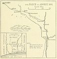 March to Abomey.jpg 1,074 × 1,122; 223 KB
-

-

-

-

-
 81 of 'De Dahomé. Souvenirs de voyage et de mission' (11102925395).jpg 2,672 × 1,560; 1,007 KB
-
 Benin-Burkina border.png 1,160 × 856; 309 KB
-
 Burkina-Togo border map.png 878 × 1,188; 280 KB
-
 Carte du Dahomey - DPLA - 048c3eae3c22a6c9bf1845b5e9d55c3a.jpg 1,000 × 683; 241 KB
-

-

-
 D295- carte des religions du Dahomey. - L1-Ch5.png 1,452 × 1,460; 34 KB
-
 Dahomey & pays limitrophes-1892 zoomed in.jpg 1,420 × 963; 506 KB
-
 Dahomey & pays limitrophes-1892.jpg 4,864 × 3,298; 7.19 MB
-

-

-
 Dahomey et Togo. Croquis routier - btv1b53192488c.jpg 6,820 × 9,816; 9.44 MB
-
 Dahomey. 2-66. LOC 76696103.jpg 4,391 × 8,056; 3.68 MB
-
 Dahomey. 2-66. LOC 76696103.tif 4,391 × 8,056; 101.21 MB
-
 Dahomey. 2-66. LOC 76696104.jpg 4,434 × 8,098; 4.1 MB
-
 Dahomey. 2-66. LOC 76696104.tif 4,434 × 8,098; 102.73 MB
-
 Dahomey. 5-70. LOC 73696400.jpg 4,482 × 8,379; 3.72 MB
-
 Dahomey. 5-70. LOC 73696400.tif 4,482 × 8,379; 107.45 MB
-
 Dahomey. 5-70. LOC gm71002133.jpg 7,927 × 8,167; 6.18 MB
-
 Dahomey. 5-70. LOC gm71002133.tif 7,927 × 8,167; 185.22 MB
-
 Fr Ouidah 1920s B002.jpg 3,263 × 3,289; 3.95 MB
-
 Fr Ouidah 1920s B002b.png 3,263 × 3,289; 3.39 MB
-
 Kingdom of Dahomy-1793.jpg 760 × 371; 56 KB
-
 Le Tour du monde-07-p067.jpg 1,623 × 1,085; 408 KB
-
 Le Tour du monde-07-p083.png 829 × 758; 176 KB
-
 Mission 1908-1910.png 2,544 × 1,682; 4.38 MB
-
 Europas Kolonien. 1 1885 (150829060).jpg 3,461 × 4,994; 10.53 MB
)_-_DPLA_-_bca944d2ec9ca428068c3410524991ac.jpg)
.jpg)
.jpg)
.jpg)
.jpg)

.jpg)
.jpg)
.jpg)
.jpg)
.jpg)


.jpg)
.jpg)