Category:Old maps of Dundee
Jump to navigation
Jump to search
Subcategories
This category has only the following subcategory.
G
Media in category "Old maps of Dundee"
The following 14 files are in this category, out of 14 total.
-

-

-
-

-
-
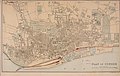
 1887 Plan of Dundee.png 1,552 × 722; 2.09 MB
-
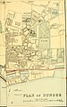
 1892 Plan of Dundee.png 1,586 × 801; 2.42 MB
-

-

-

-
 Admiralty Chart No 1481 River Tay, Published 1960.jpg 9,889 × 6,785; 26.12 MB
-
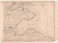 Admiralty Chart No 1407 Scotland E. Coast Sheet 1 Eyemouth to the Tay, Published 1842.jpg 11,061 × 8,211; 15.48 MB
-

-
 Ordnance Survey One-Inch Sheet 64 Dundee & St Andrews, Published 1945.jpg 14,463 × 10,617; 15.63 MB
.jpg)
_(14800389023).jpg)
_(14598417508).jpg)
_(14804909113).jpg)
_(14587730988).jpg)


.jpg)
.jpg)
.jpg)


_(14772022194).jpg)
