Category:Old maps of Ethiopia
Jump to navigation
Jump to search
Countries of Africa: Algeria · Angola · Benin · Botswana · Burkina Faso · Burundi · Cameroon · Cape Verde · Central African Republic · Chad · Comoros · Democratic Republic of the Congo · Republic of the Congo · Djibouti · Egypt‡ · Equatorial Guinea · Eritrea · Eswatini · Ethiopia · Gabon · The Gambia · Ghana · Guinea · Guinea-Bissau · Ivory Coast · Kenya · Lesotho · Liberia · Libya · Madagascar · Malawi · Mali · Mauritania · Mauritius · Morocco · Mozambique · Namibia · Niger · Nigeria · Rwanda · São Tomé and Príncipe · Senegal · Sierra Leone · Somalia · South Africa · South Sudan · Sudan · Tanzania · Togo · Tunisia · Uganda · Zambia · Zimbabwe
Limited recognition: Puntland · Somaliland – Other areas: Canary Islands · Ceuta · Madeira · Mayotte · Melilla · Réunion
‡: partly located in Africa
Limited recognition: Puntland · Somaliland – Other areas: Canary Islands · Ceuta · Madeira · Mayotte · Melilla · Réunion
‡: partly located in Africa
Use the appropriate category for maps showing all or a large part of Ethiopia. See subcategories for smaller areas:
| If the map shows | Category to use |
|---|---|
| Ethiopia on a recently created map | Category:Maps of Ethiopia or its subcategories |
| Ethiopia on a map created more than 70 years ago | Category:Old maps of Ethiopia or its subcategories |
| the history of Ethiopia on a recently created map | Category:Maps of the history of Ethiopia or its subcategories |
| the history of Ethiopia on a map created more than 70 years ago | Category:Old maps of the history of Ethiopia or its subcategories |
Subcategories
This category has the following 10 subcategories, out of 10 total.
Media in category "Old maps of Ethiopia"
The following 103 files are in this category, out of 103 total.
-
 (Croquis de l’Ethiopie) - DPLA - c53d23b36faefc60c4b605a29800b8fd.jpg 914 × 1,000; 162 KB
-
 Plan of the Ruins of Axum Salt Cooper.jpg 1,500 × 937; 286 KB
-
 Henry Salt - Ground plan of the ruins of Axum.jpg 1,617 × 999; 260 KB
-

-
-

-
 Henry Salt - Part of Abyssinia, as laid down by Ludolf (Plate 17.).jpg 4,866 × 3,029; 2.04 MB
-
 Henry Salt - Part of Abyssinia, as laid down by Ludolf.jpg 1,247 × 773; 518 KB
-

-

-
 1835 Axum detail map Northern Africa by Thomas Bradford BPL m0612003.png 1,068 × 748; 1.34 MB
-

-
 273 of 'Through Abyssinia. An envoy's ride to the King of Zion' (11202459424).jpg 2,867 × 2,050; 792 KB
-

-
 293 of 'My Mission to Abyssinia ... With maps and illustrations' (11218259456).jpg 3,865 × 3,302; 3.18 MB
-

-

-

-

-

-

-

-

-

-

-

-

-

-

-

-
 561 of '(With eleven maps.)' (11100969286).jpg 6,859 × 3,537; 4.19 MB
-
 575 of '(With eleven maps.)' (11101754225).jpg 4,687 × 3,490; 2.16 MB
-
 637 of 'Douze Ans dans la Haute-Éthiopie. (With a map.) tom. 1' (11085303644).jpg 3,502 × 5,150; 3.87 MB
-

-
 Abisynia 1584.jpg 586 × 509; 119 KB
-
 Adwa Map Menelik progression before battle of Adwa.jpg 857 × 853; 265 KB
-
 Adwa map.jpg 709 × 972; 134 KB
-
 Bruce Battle of Sarbakusa01.jpg 2,048 × 2,729; 516 KB
-
 Bruce Battle of Sarbakusa02.jpg 2,048 × 2,670; 478 KB
-
 Bruce Battles of Sarbakusa03.jpg 2,047 × 2,723; 527 KB
-
 Ca000004.jpg 2,500 × 3,542; 1.82 MB
-
 Ca000005.jpg 2,700 × 1,436; 705 KB
-
 Chart of the Red Sea from Salaka to Suez, 1804-1805.jpg 920 × 1,179; 121 KB
-

-

-
 Eritrea and Ethiopia. LOC 2010587913.tif 5,920 × 7,361; 124.68 MB
-
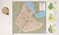
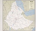
 Ethiopia LOC 2005631130.jpg 7,798 × 7,076; 6.11 MB
-
 Ethiopia LOC 2005631130.tif 7,798 × 7,076; 157.87 MB
-
 Ethiopia LOC 85690517.jpg 12,238 × 7,231; 11.13 MB
-
 Ethiopia LOC 85690517.tif 12,238 × 7,231; 253.18 MB
-
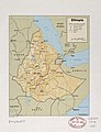
 Ethiopia, administrative divisions. LOC 94686091.jpg 2,874 × 3,484; 1.24 MB
-
 Ethiopia, administrative divisions. LOC 94686091.tif 2,874 × 3,484; 28.65 MB
-
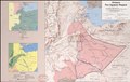
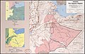 Ethiopia, the Ogaden Region. LOC 91682434.jpg 6,747 × 4,269; 3.53 MB
-
 Ethiopia, the Ogaden Region. LOC 91682434.tif 6,747 × 4,269; 82.41 MB
-
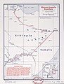 Ethiopia-Somalia boundary. LOC 84692130.jpg 3,178 × 4,200; 1.22 MB
-
 Ethiopia-Somalia boundary. LOC 84692130.tif 3,178 × 4,200; 38.19 MB
-
 Ethiopia. 9-72. LOC 74692474.jpg 7,743 × 6,702; 6.17 MB
-
 Ethiopia. 9-72. LOC 74692474.tif 7,743 × 6,702; 148.47 MB
-
 Ethiopia. 9-72. LOC 75692879.jpg 9,817 × 7,027; 7.84 MB
-
 Ethiopia. 9-72. LOC 75692879.tif 9,817 × 7,027; 197.37 MB
-
 Ethiopia. LOC 00556309.jpg 3,334 × 4,356; 1.7 MB
-
 Ethiopia. LOC 00556309.tif 3,334 × 4,356; 41.55 MB
-
 Ethiopia. LOC 00556310.jpg 2,136 × 2,832; 806 KB
-
 Ethiopia. LOC 00556310.tif 2,136 × 2,832; 17.31 MB
-
 Ethiopia. LOC 84696846.jpg 3,331 × 4,324; 1.38 MB
-
 Ethiopia. LOC 84696846.tif 3,331 × 4,324; 41.21 MB
-
 Ethiopia. LOC 84696847.jpg 3,330 × 4,340; 1.42 MB
-
 Ethiopia. LOC 84696847.tif 3,330 × 4,340; 41.35 MB
-
 Ethiopia. LOC 91681397.jpg 3,315 × 4,331; 1.52 MB
-
 Ethiopia. LOC 91681397.tif 3,315 × 4,331; 41.08 MB
-
 Ethiopia. LOC 91681422.jpg 3,322 × 4,346; 1.48 MB
-
 Ethiopia. LOC 91681422.tif 3,322 × 4,346; 41.31 MB
-
 Ethiopia. LOC 97687599.jpg 3,151 × 4,159; 1.31 MB
-
 Ethiopia. LOC 97687599.tif 3,151 × 4,159; 37.49 MB
-
 Ethiopia. LOC 97687600.jpg 3,141 × 4,187; 1.45 MB
-
 Ethiopia. LOC 97687600.tif 3,141 × 4,187; 37.63 MB
-
 Ethiopia. LOC 97687603.jpg 3,186 × 4,215; 1.17 MB
-
 Ethiopia. LOC 97687603.tif 3,186 × 4,215; 38.42 MB
-
 Fazughli and the Blue Nile.jpg 1,500 × 1,542; 1.28 MB
-
 Fullarton6a 1860s Map of Central Africa.jpg 1,363 × 735; 301 KB
-
 Fullarton8 1860s Map of Central Africa.jpg 1,358 × 739; 258 KB
-
 Gondar sector, East African Campaign.jpg 1,014 × 1,630; 1,022 KB
-

-
 Image taken from page 563 of '(With eleven maps.)' (11100091176).jpg 6,896 × 3,535; 3.92 MB
-
 Image taken from page 565 of '(With eleven maps.)' (11100162396).jpg 5,999 × 3,448; 3.28 MB
-
 Image taken from page 567 of '(With eleven maps.)' (11100838655).jpg 6,842 × 3,506; 3.91 MB
-
 Image taken from page 569 of '(With eleven maps.)' (11100048344).jpg 6,051 × 3,402; 3.17 MB
-
 Image taken from page 571 of '(With eleven maps.)' (11101165775).jpg 4,603 × 3,514; 2.52 MB
-

-
 ItalianDanakilCoast.jpg 1,170 × 1,590; 234 KB
-
 Itinerario del viaggio in Abissinia fatto da Pippo Vigoni nel 1879.jpg 894 × 1,428; 268 KB
-

-

-
 Location of the border between Tigray and Amhara.png 1,027 × 244; 47 KB
-
 Major clan areas in Somaliland and neighboring territories.png 644 × 405; 103 KB
-
 Map of Abyssinia in1800 .jpg 838 × 1,024; 186 KB
-
 Map of the frontier between British East Africa and Abyssinia in 1902-3.jpg 5,000 × 3,146; 3.12 MB
-
 Scottish geographical magazine (1885) (14596538400).jpg 2,102 × 818; 305 KB
-
 Sketch Chart of Abyssinia.png 1,291 × 1,546; 2.52 MB
-
 Territorial control of Welkait according to historical maps.png 1,027 × 286; 38 KB
-
 The earth and its inhabitants (1886) (20938162020).jpg 2,054 × 3,154; 1.85 MB
-
 Timeline of the location of the boundary between Amhara and Tigray.png 1,027 × 148; 32 KB
-
 Ethiopie. Chiquet L'Afrique 1719 UTA (cropped).jpg 613 × 605; 424 KB
_-_DPLA_-_c53d23b36faefc60c4b605a29800b8fd.jpg)


%27_(11001451674).jpg)
%27_(11001447166).jpg)
%27_(11202818695).jpg)
.jpg)

%27_(11001505323).jpg)
%27_(11001393716).jpg)

.jpg)
.jpg)
.jpg)
.jpg)
.jpg)
%27_(11205835394).jpg)
%27_(11204662906).jpg)
%27_(11205715895).jpg)
%27_(11203444163).jpg)
.jpg)
%27_(11202659735).jpg)
%27_(11205489423).jpg)
)%27_(11103115475).jpg)
%27_(11093416564).jpg)
%27_(11203333625).jpg)
%27_(11202775595).jpg)
.jpg)
%27_(11204757786).jpg)
%27_(11092619544).jpg)
%27_(11100969286).jpg)
%27_(11101754225).jpg)
_tom._1%27_(11085303644).jpg)
.jpg)


.jpg)


.jpg)
%27_(11100091176).jpg)
%27_(11100162396).jpg)
%27_(11100838655).jpg)
%27_(11100048344).jpg)
%27_(11101165775).jpg)
.jpg)


_(20938162020).jpg)
.jpg)
_(14596538400).jpg)