Category:Old maps of Grand Rapids, Michigan
Jump to navigation
Jump to search
Subcategories
This category has only the following subcategory.
S
Media in category "Old maps of Grand Rapids, Michigan"
The following 14 files are in this category, out of 14 total.
-
 1833 plat map of Grand Rapids.tif 568 × 577; 440 KB
-
 1853 Grand Rapids, Michigan.jpg 6,500 × 4,982; 9.82 MB
-

-
-
-
-

-

-
 Gr-1924-streetcar-map.jpg 1,440 × 1,920; 880 KB
-
 Grand Rapids inset, October 1, 1957.png 536 × 537; 790 KB
-
 Grand Rapids street car lines 1921 GRPL.jpg 2,171 × 2,763; 3.58 MB
-
 Grand Rapids, Michigan 1868. LOC 73693428.jpg 10,555 × 6,828; 12.92 MB
-
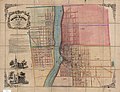
 MI Grand Rapids 1868.jpg 2,638 × 1,706; 1.12 MB
-
 1903 gr railway map.jpg 3,583 × 5,135; 2.44 MB

.jpg)
.jpg)
.jpg)
.jpg)
_-_Kent_County_-_Grand_Rapids_-_ED_87-1_to_276_-_NARA_-_16870078.jpg)
_-_Kent_County_-_Grand_Rapids_Urbanized_Area_-_ED_41-7_to_9,_41-11_to_12,_41-32_to_34,_41-37_to_48,_41-62_to_68,_41-72_to_74,_41-91,_41-93_to_100,_41-102_to_121_-_NARA_-_16870081.jpg)


