Category:Old maps of Mexico City
Jump to navigation
Jump to search
Subcategories
This category has the following 7 subcategories, out of 7 total.
- 19th-century maps of Mexico City (31 F)
Media in category "Old maps of Mexico City"
The following 19 files are in this category, out of 19 total.
-
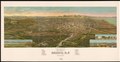
 Plano perspectivo de la ciudad y del valle de Mexico D.F. LOC 2019360372.jpg 12,323 × 6,351; 13.36 MB
-
 Plano perspectivo de la ciudad y del valle de Mexico D.F. LOC 2019360372.tif 12,323 × 6,351; 223.91 MB
-
 CALLEJA (1924) 06.jpg 4,056 × 2,621; 9.35 MB
-
 Ciudad de Mexico, 1900.jpg 1,578 × 1,216; 1.4 MB
-
 CORTL V1 D211 Plan of Mexico Tenochtitlan.jpg 2,027 × 2,879; 481 KB
-
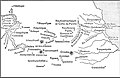 HHBHM V1 D316 Central and eastern Mexico map.jpg 1,853 × 1,197; 306 KB
-
 HHBHM V1 D522 Area surrounding Mexico City.jpg 1,883 × 994; 151 KB
-
 HHBHM V1 D612 Towns surrounding Mexico City.jpg 1,547 × 837; 91 KB
-
 HHBHM V2 D575 Central Mexico and the City.jpg 1,300 × 2,199; 434 KB
-
 Mexico Tramways Company - Lines and properties in Mexico City LOC 2012593202.jpg 6,548 × 4,698; 4.11 MB
-
 Mexico Tramways Company - Lines and properties in Mexico City LOC 2012593202.tif 6,548 × 4,698; 88.01 MB
-
 Plan de Mexico et de ses environs (34458777021).jpg 6,955 × 10,314; 42.06 MB
-
 Plano de la ciudad de guadalupe hidalgo.png 1,200 × 916; 618 KB
-
 Plano de la Ciudad de Mexico LOC 2012592176.jpg 16,506 × 12,598; 27.44 MB
-
 Plano de la Ciudad de México LOC 2012592177.jpg 16,944 × 12,657; 28.31 MB
-
 Plano de la Ciudad de México LOC 2012592177.tif 16,944 × 12,657; 613.58 MB
-

-
 Plans of Inland Towns -3-.jpg 4,017 × 2,819; 1.19 MB
-


_06.jpg)


.jpg)


