Category:Old maps of Michigan from the Norman B. Leventhal Map Center
Jump to navigation
Jump to search
Media in category "Old maps of Michigan from the Norman B. Leventhal Map Center"
The following 21 files are in this category, out of 21 total.
-
 Alma, Michigan (2674973865).jpg 2,000 × 1,566; 2.22 MB
-
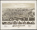
 Birds eye view of Hancock, L.S. Mich, 1873 (2675795664).jpg 2,000 × 1,557; 3 MB
-
 Birds eye view of Houghton, L.S., Michigan, 1872 (2675796710).jpg 2,000 × 1,517; 3.04 MB
-
 Birds eye view of Ishpeming, L.S., Michigan (2674979621).jpg 2,000 × 1,620; 3.31 MB
-
 Cities of East Saginaw and Saginaw, Michigan, 1885 (2675801518).jpg 2,000 × 1,517; 3.11 MB
-
 Coleman, Michigan (2675794260).jpg 2,000 × 1,346; 2.24 MB
-
 Map of Calhoun County, Michigan (14773867609).jpg 1,868 × 2,000; 4.16 MB
-
 Map of Hillsdale Co., Michigan (14773866819).jpg 1,845 × 2,000; 3.7 MB
-
 Map of Jackson County, Michigan (14773939558).jpg 2,000 × 1,882; 3.97 MB
-
 Map of Kalamazoo Co., Michigan (13405942373).jpg 2,000 × 1,983; 3.83 MB
-
 Map of Lapeer Co., Michigan (13405941793).jpg 1,843 × 2,000; 3.39 MB
-
 Map of Monroe County, Michigan (13384899153).jpg 2,000 × 1,456; 2.77 MB
-
 Map of the counties of Eaton and Barry, Michigan (13405943643).jpg 2,000 × 1,729; 3.78 MB
-
 Map of the counties of Macomb and St. Clair, Michigan (14960193252).jpg 2,000 × 1,726; 3.91 MB
-
 Map of the counties of Washtenaw and Lenawee, Michigan (14782734169).jpg 2,000 × 1,972; 4.59 MB
-
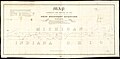
 Map, boundary, Michigan and Ohio (8347660926).jpg 9,784 × 5,559; 6.44 MB
-
-
 Midland City, Michigan (2674980989).jpg 2,000 × 1,561; 2.68 MB
-
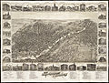
 Mt. Pleasant, Michigan.jpg 2,000 × 1,593; 2.56 MB
-
 Political map of Michigan 1888 (7557603086).jpg 1,424 × 2,000; 2.63 MB
-
 Portion of the copper district, Michigan, Lake Superior (13410195344).jpg 1,439 × 2,000; 2.68 MB
.jpg)
.jpg)
.jpg)
.jpg)
.jpg)
.jpg)
.jpg)
.jpg)
.jpg)
.jpg)
.jpg)
.jpg)
.jpg)
.jpg)
.jpg)
.jpg)
.jpg)
.jpg)

.jpg)
.jpg)