Category:Old maps of Rennes
Jump to navigation
Jump to search
Subcategories
This category has the following 2 subcategories, out of 2 total.
Media in category "Old maps of Rennes"
The following 60 files are in this category, out of 60 total.
-
 1Fi1 plan de l'incendie de Rennes.jpg 9,284 × 8,233; 7.38 MB
-
 1Fi108 Plan de Rennes 1914.jpg 9,979 × 7,926; 6.58 MB
-
 1Fi109 plan d'extension de Rennes 1919.jpg 8,811 × 7,427; 7.18 MB
-
 1fi117 Plan de Rennes de 1942.jpg 6,197 × 4,478; 2.2 MB
-
 1fi73 Plan de la ville de Rennes.jpg 7,532 × 5,535; 2.99 MB
-
 1fi74 Plan de Rennes avec gare.jpg 6,741 × 4,839; 2.59 MB
-
 1fi76 plan de Rennes.jpg 5,685 × 4,301; 2.4 MB
-
 1fi77-Plan de Rennes et des environs en 1857.jpg 9,503 × 6,762; 3.95 MB
-
 2fi1341 Ecole de médecine de Rennes.jpg 8,459 × 6,001; 2.25 MB
-
 2fi1500 Projet de faculté des sciences de Rennes.jpg 5,489 × 4,046; 1.01 MB
-
 2fi1673 Rennes église Saint-Aubin.jpg 5,595 × 8,150; 3.62 MB
-
 2Fi1688 Rennes église Saint-Aubin.jpg 3,399 × 4,792; 755 KB
-
 2fi1691 Rennes plan de Rennes.jpg 7,877 × 5,519; 4 MB
-
 2fi2295 Palais Saint-Georges de Rennes.jpg 10,645 × 5,350; 2.84 MB
-
 2Fi2296 Palais Saint-Georges de Rennes.jpg 10,975 × 5,594; 6.77 MB
-
 2fi2297 Palais Saint-Georges de Rennes.jpg 8,363 × 5,661; 1.47 MB
-
 2fi2298 Palais Saint-Georges de Rennes.jpg 8,340 × 5,554; 1.82 MB
-
 2fi2673 Plan du lycée impérial.jpg 8,086 × 5,475; 1.58 MB
-
 2fi3749 Projet d'octroi au Mail - Rennes.jpg 4,961 × 4,192; 1,011 KB
-
 2fi387 Projet de faculté des sciences de Rennes.jpg 8,118 × 5,760; 1.54 MB
-
 2fi4298.jpg 3,888 × 3,166; 469 KB
-
 2Fi4299.jpg 4,349 × 3,547; 1.28 MB
-
 2fi4890 Palais du Commerce de Rennes et quai Pré-botté.jpg 7,870 × 5,299; 2.02 MB
-
 2fi4962 Rennes Maison du Peuple.jpg 3,504 × 4,420; 575 KB
-
 2fi4965 Rennes Maison du peuple.jpg 3,662 × 4,770; 1.04 MB
-
 2fi559 Plan du palais du commerce à Rennes.jpg 5,653 × 3,346; 890 KB
-
 2fi561 Plan du palais du commerce à Rennes.jpg 8,262 × 5,857; 1.65 MB
-
 2fi683 plan de la gare.jpg 8,448 × 6,011; 1.5 MB
-
 3fi32 Plan des enclos de l'abbaye de Saint-Georges.jpg 4,825 × 4,697; 1.68 MB
-
-

-

-
 Copie d'un plan du Parlement de Bretagne établi en 1618.jpg 1,546 × 2,023; 3.58 MB
-
 Ecole nationale d’agriculture de Rennes plan 1922.jpg 3,161 × 3,084; 1.91 MB
-
 Jardin des Plantes de la Ville de Rennes 1867.jpg 828 × 580; 144 KB
-
 Jean-Baptiste Martenot signature (cropped).jpg 1,055 × 490; 80 KB
-
 Plan de l'hopital général de la ville de Rennes.jpg 12,332 × 11,868; 13.35 MB
-
 Plan de l'incendie de la ville de Rennes (Isaac Robelin, 1722).jpg 9,518 × 8,071; 9.64 MB
-

-
-
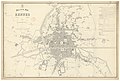
 Plan de la ville de Rennes (Ad. Periaux, 1829).jpg 7,107 × 5,492; 4.66 MB
-
 Plan de la ville de Rennes - btv1b530302232.jpg 10,413 × 7,070; 10.18 MB
-
 Plan de la ville de Rennes - lith. Landais & Oberthur - btv1b53087941m.jpg 10,616 × 7,192; 9.45 MB
-
 Plan de la ville de Rennes en 1948.jpg 11,382 × 8,755; 9.28 MB
-
 Plan de la Ville de Rennes et de ſes Fauxbourgs (Cassini De Thury, 1782).jpg 5,459 × 4,970; 4.69 MB
-

-
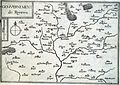
 Plan de Rennes (1618).jpg 5,019 × 2,651; 1.73 MB
-
 Plan de Rennes (1885).jpg 7,976 × 5,991; 4.62 MB
-
-
 Plan de Rennes sous la 2nd Guerre Mondiale - Musée de Bretagne - 994.0045.31.jpg 1,500 × 1,064; 959 KB
-
 Plan-Reverdiais- Antrain.jpg 2,178 × 1,956; 1.11 MB
-
 Plans et vues de Bretagne - btv1b531567211 (16 of 16).jpg 1,878 × 1,309; 603 KB
-
 Rennes at the 17th century Henri Carré's map-fr.svg 1,270 × 1,235; 118 KB
-
 Rennes plan du moulin de Trublet 1860.jpg 2,409 × 1,615; 873 KB
-
 Rennes Tassin 5992.jpg 3,349 × 2,376; 7.74 MB
-
 Rennes Tassin 5993.jpg 3,344 × 2,315; 8.13 MB
-
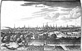 RenneS Zeiller 15095.jpg 4,103 × 2,552; 6.43 MB
-
 RENNES-PLAN du 18e siècle La Moussaye.jpg 1,371 × 1,362; 568 KB
-
 RENNES-PLAN MOUSSAYE du 18e siècle.jpg 972 × 1,434; 453 KB
-
 Tabula ducatus britanniae gallis - Sud Rennes.png 466 × 398; 298 KB


_-_Plan_de_la_ville_de_Rennes_avec_indication_des_travaux_ex%C3%A9cut%C3%A9s_depuis_1855_(A._C._Rennes,_1_Fi_76)._HR.jpg)
_-_Plan_annex%C3%A9_au_dossier_de_classement_de_la_voie_en_1861_(A._C._Rennes).jpg)
.jpg)


.jpg)

.jpg)
.jpg)

.jpg)


.jpg)

.jpg)
.jpg)


.jpg)


