Category:Old maps of cities in Connecticut
Jump to navigation
Jump to search
States of the United States: Alabama · Alaska · Arizona · Arkansas · California · Colorado · Connecticut · Delaware · Florida · Georgia · Hawaii · Idaho · Illinois · Indiana · Iowa · Kansas · Kentucky · Louisiana · Maine · Maryland · Massachusetts · Michigan · Minnesota · Mississippi · Missouri · Montana · Nebraska · Nevada · New Hampshire · New Jersey · New Mexico · New York · North Carolina · North Dakota · Ohio · Oklahoma · Oregon · Pennsylvania · Rhode Island · South Carolina · South Dakota · Tennessee · Texas · Utah · Vermont · Virginia · Washington · West Virginia · Wisconsin · Wyoming
Subcategories
This category has only the following subcategory.
S
Media in category "Old maps of cities in Connecticut"
The following 16 files are in this category, out of 16 total.
-

-
 1875 Danbury picture map.jpg 3,309 × 2,664; 2.45 MB
-
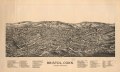
 Bird's eye view of Bristol, Conn. 1907. LOC 75693147.jpg 10,752 × 9,568; 18.37 MB
-
 Bird's eye view of Bristol, Conn. 1907. LOC 75693147.tif 10,752 × 9,568; 294.33 MB
-
 Bristol, Conn. looking north-east. LOC 75693146.jpg 13,538 × 8,122; 18.23 MB
-
 Bristol, Conn. looking north-east. LOC 75693146.tif 13,538 × 8,122; 314.59 MB
-
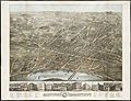
 City of Derby, Connecticut. LOC 73694677.jpg 6,464 × 4,992; 5.21 MB
-
 City of Derby, Connecticut. LOC 73694677.tif 6,464 × 4,992; 92.32 MB
-
 Derby, Shelton, and East Derby, Conn., 1898. LOC 99462706.jpg 11,543 × 8,556; 27.42 MB
-
 Derby, Shelton, and East Derby, Conn., 1898. LOC 99462706.tif 11,543 × 8,556; 282.56 MB
-
 Little Liberia (Bridgeport, Connecticut) 1850.png 1,167 × 1,265; 926 KB
-
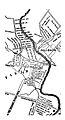
 Map of New Milford, Litchfield Co., Conn. (10212587553).jpg 800 × 715; 137 KB
-

-
 Map-windsor-closeup-1654.jpg 500 × 924; 44 KB
-
 Map-windsor-connecticut-1654.jpg 1,000 × 1,709; 765 KB
-
 OldHartfordMap.jpg 10,080 × 7,712; 34.46 MB
.jpg)


_1850.png)
.jpg)
.jpg)


