Category:Old topographic maps of Gers
Jump to navigation
Jump to search
Media in category "Old topographic maps of Gers"
The following 8 files are in this category, out of 8 total.
-
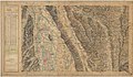
 Carte d'État-major de la France, Feuille Auch N.E.jpg 24,371 × 14,614; 127.41 MB
-
 Carte d'État-major de la France, Feuille Auch N.O.jpg 24,142 × 14,540; 130.44 MB
-
 Carte d'État-major de la France, Feuille Auch S.E.jpg 24,142 × 14,362; 130.5 MB
-
 Carte d'État-major de la France, Feuille Auch S.O.jpg 24,142 × 14,505; 131.76 MB
-
 Carte d'État-major de la France, Feuille Castelnau N.E.jpg 24,142 × 14,537; 125.77 MB
-
 Carte d'État-major de la France, Feuille Castelnau N.O.jpg 24,142 × 14,317; 121.37 MB
-
 Carte d'État-major de la France, Feuille Castelnau S.E.jpg 23,622 × 13,694; 114.7 MB
-
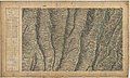
 Carte d'État-major de la France, Feuille Saint-Gaudens N.O.jpg 24,094 × 14,371; 124.95 MB


