Category:Oldehove
Jump to navigation
Jump to search
| Object location | | View all coordinates using: OpenStreetMap |
|---|
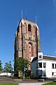
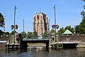
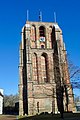
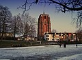
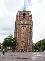
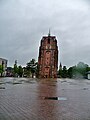
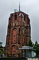
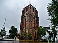
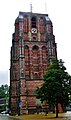
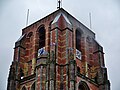
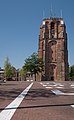
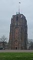
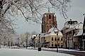
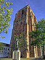
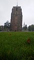
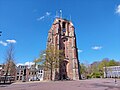
iconic leaning tower in Leeuwarden, Friesland, the Netherlands      | |||||
| Upload media | |||||
| Instance of | |||||
|---|---|---|---|---|---|
| Part of | |||||
| Made from material | |||||
| Location | Leeuwarden, Friesland, Netherlands | ||||
| Street address |
| ||||
| Located on street | |||||
| Architectural style | |||||
| Heritage designation |
| ||||
| Inception |
| ||||
| Significant event |
| ||||
| Height |
| ||||
| Religion or worldview | |||||
 | |||||
Nederlands: De Oldehove (Fries: Aldehou) is een scheve kerktoren in Leeuwarden die nooit is afgebouwd.
|
This is a category about rijksmonument number 24331
|
| Address |
|
Subcategories
This category has the following 3 subcategories, out of 3 total.
Media in category "Oldehove"
The following 75 files are in this category, out of 75 total.
-
 19-08-07 leeuwarden.jpg 960 × 1,280; 227 KB
-
 1983-07 175 Leeuwarden, scheve kerktoren.jpg 2,362 × 3,543; 2.59 MB
-
 20140531 Oldehove (Aldehou) Leeuwarden NL.jpg 2,400 × 3,600; 2.63 MB
-
 20180719 430 leeuwarden.jpg 6,000 × 4,000; 11.9 MB
-
 20180719 536 leeuwarden.jpg 4,000 × 6,000; 9.45 MB
-
 20180719 544 leeuwarden.jpg 6,000 × 4,000; 8.81 MB
-
 20180719 548 leeuwarden.jpg 6,000 × 4,000; 8.46 MB
-
 20180720 027 leeuwarden.jpg 4,000 × 6,000; 10.47 MB
-
 20180720 028 leeuwarden.jpg 6,000 × 4,000; 8.46 MB
-
 20180720 029 leeuwarden.jpg 6,000 × 4,000; 8.6 MB
-
 20180720 030 leeuwarden.jpg 6,000 × 4,000; 8.63 MB
-
 20180720 031 leeuwarden.jpg 6,000 × 4,000; 8.84 MB
-
 20180720 032 leeuwarden.jpg 6,000 × 4,000; 9.43 MB
-
 20180720 033 leeuwarden.jpg 6,000 × 4,000; 9.22 MB
-
 20180720 034 leeuwarden.jpg 6,000 × 4,000; 13.97 MB
-
 20180720 249 leeuwarden.jpg 4,000 × 6,000; 11.78 MB
-
 20180720 254 leeuwarden.jpg 6,000 × 4,000; 11.53 MB
-
 20180720 255 leeuwarden.jpg 6,000 × 4,000; 11.43 MB
-
 20190227 Oldehove Leeuwarden.jpg 3,456 × 5,184; 3.64 MB
-
 20200922 Oldehove Leeuwarden.jpg 5,184 × 3,456; 4 MB
-
 20200922 Oldehove1 Leeuwarden.jpg 3,024 × 4,032; 2.16 MB
-
 Aldehou, Ljouwert.jpg 1,764 × 1,276; 1.13 MB
-
 Broedende stadsduif in de Oldehove.JPG 4,592 × 3,056; 5.41 MB
-
 De Aldehou, Ljouwert.jpg 2,000 × 1,444; 1,023 KB
-
 De Oldenhove Leeuwarden (4229063914).jpg 1,024 × 681; 227 KB
-
 Der schiefe Turm von Leeuwarden - Oldehove (2023).jpg 3,600 × 4,800; 9.52 MB
-
 Dominicuskerk Leeuwarden.jpg 3,427 × 2,567; 2.97 MB
-
 Eelke Jelles Eelkema - Gezicht op de Oldehove.jpg 439 × 558; 37 KB
-
 Leeuwarden - panoramio - L-BBE (25).jpg 5,515 × 3,677; 7.15 MB
-
 Leeuwarden - panoramio - L-BBE (30).jpg 3,744 × 5,616; 7.02 MB
-
 Leeuwarden Oldehove 01.jpg 3,448 × 4,592; 5.49 MB
-
 Leeuwarden Oldehove 02.jpg 2,448 × 3,766; 3.74 MB
-
 Leeuwarden Oldehove 03.jpg 3,338 × 4,269; 6.56 MB
-
 Leeuwarden Oldehove 04.jpg 4,590 × 3,446; 6.14 MB
-
 Leeuwarden Oldehove 05.jpg 3,421 × 3,996; 4.18 MB
-
 Leeuwarden Oldehove 06.jpg 2,545 × 4,310; 4.62 MB
-
 Leeuwarden Oldehove 07.jpg 3,448 × 4,592; 7.37 MB
-
 Leeuwarden Oldehove 08.jpg 3,448 × 4,592; 6.21 MB
-
 Leeuwarden Oldehove 09.jpg 3,414 × 4,566; 6.96 MB
-
 Leeuwarden Oldehove 10.jpg 4,569 × 3,079; 5.92 MB
-
 Leeuwarden Oldehove 11.jpg 4,576 × 3,069; 6.82 MB
-
 Leeuwarden Oldehove 12.jpg 4,570 × 3,418; 5.63 MB
-
 Leeuwarden — Oldehove in winter.jpg 3,000 × 4,000; 2.68 MB
-
 Leeuwarden, de Oldehove RM24331 IMG 3650 2018-05-21 11.29.jpg 3,309 × 5,360; 10.06 MB
-
 Leeuwarden, de Oldehove RM24331 in straatzicht IMG 3748 2018-05-23 15.02.jpg 3,698 × 3,070; 7.86 MB
-
 Leeuwarden, het plein voor de Oldehove IMG 3744 2018-05-21 14.47.jpg 4,965 × 3,310; 8.43 MB
-
 Leeuwarden, Netherlands - panoramio (26).jpg 2,323 × 2,322; 2.13 MB
-
 Leeuwarden, Oldehoven foto1 2009-09-19 09.19.JPG 2,592 × 3,456; 932 KB
-
 Leeuwarden-Oldehove (1).jpg 2,988 × 5,312; 2.62 MB
-
 Leeuwarden-Oldehove (2).jpg 2,988 × 5,312; 1.65 MB
-
 Leeuwarden-Oldehove (3).jpg 5,312 × 2,988; 2.37 MB
-
 Leeuwarden-Oldehove (4).jpg 2,988 × 5,312; 1.84 MB
-
 Leeuwarden3.jpg 1,536 × 2,048; 1.07 MB
-
 Leeuwardenoldehove.JPG 375 × 500; 21 KB
-
 Ljouwert, Westerplantaazje.jpg 2,000 × 1,332; 989 KB
-
 Oldehove - Bert Kaufmann.jpg 3,017 × 3,970; 4.51 MB
-
 Oldehove 1584.jpg 4,632 × 3,464; 8.9 MB
-
 Oldehove church Leeuwarden 1.jpg 3,264 × 4,928; 6.61 MB
-
 Oldehove church Leeuwarden 2.jpg 3,264 × 4,928; 8.12 MB
-
 Oldehove church Leeuwarden 3.jpg 3,264 × 4,928; 8.56 MB
-
 Oldehove door Stellingwerf in 1723.tif 1,341 × 1,092; 4.19 MB
-
 Oldehove Leeuwarden 2010.jpg 1,719 × 2,996; 892 KB
-
 Oldehove Leeuwarden.jpg 2,229 × 1,732; 3.01 MB
-
 Oldehove Oldehoofsterkerkhof Leeuwarden Nederland.JPG 1,944 × 2,592; 2.24 MB
-
 Oldehove toren Leeuwarden.jpg 2,448 × 3,264; 1.34 MB
-
 Oldehove tower Leeuwarden.jpg 3,264 × 4,928; 5.64 MB
-
 Oldehove.jpg 1,303 × 977; 304 KB
-
 Oldenhove Tower (2406052042).jpg 1,024 × 685; 183 KB
-
 RM24331 Leeuwarden - Oldehoofsterkerkhof.jpg 1,888 × 1,712; 663 KB
-
 Standbeeld Pieter-Jelles-Troelstra Oldehoofsterkerkhof Leeuwarden Nederland.JPG 1,944 × 2,592; 2.98 MB
-
 Uitsnede van Oldehove van de oudste map van Leeuwarden door Jacob Heeres - +-1553.tif 1,248 × 1,641; 5.86 MB
-
 Uitsnede van omgeving Oldehove aan het begin van de 17e eeuw door Sems.tif 1,371 × 1,104; 4.33 MB
-
 Westerplantage and Oldehove.jpg 2,736 × 3,648; 5.72 MB
-
 WLM - 23dingenvoormusea - Oldehove.jpg 3,888 × 2,592; 5.03 MB
-
 Zicht vanuit het oosten - Leeuwarden - 20326062 - RCE.jpg 931 × 1,200; 157 KB


_Leeuwarden_NL.jpg)


.jpg)
.jpg)


.jpg)
.jpg)


.jpg)

.jpg)
.jpg)
.jpg)
.jpg)


.jpg)


