Category:Oost Leeuwenstein (Heinenoord)
Jump to navigation
Jump to search
| Object location | | View all coordinates using: OpenStreetMap |
|---|
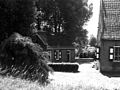
farmhouse in Binnenmaas, Netherlands  | |||||
| Upload media | |||||
| Instance of | |||||
|---|---|---|---|---|---|
| Location | Heinenoord, Hoeksche Waard, South Holland, Netherlands | ||||
| Street address |
| ||||
| Located on street |
| ||||
| Heritage designation |
| ||||
 | |||||
Nederlands: Boerderij Oost Leeuwenstein
|
This is a category about rijksmonument number 21351
|
| Address |
|
Media in category "Oost Leeuwenstein (Heinenoord)"
The following 8 files are in this category, out of 8 total.
-
 Bakhuis en woongedeelte boerderij kleur - Heinenoord - 20506448 - RCE.jpg 1,200 × 900; 239 KB
-
 Dorpstraat13.jpg 3,528 × 2,352; 6.61 MB
-
 Oost Leeuwenstein - Heinenoord - 20106970 - RCE.jpg 1,200 × 802; 180 KB
-
 Overzicht boerderij met zomerhuis - Heinenoord - 20377402 - RCE.jpg 1,200 × 956; 246 KB
-
 Smeedijzeren inrijhek kleur - Heinenoord - 20506447 - RCE.jpg 1,200 × 900; 229 KB
-
 Voorgevel - Heinenoord - 20506451 - RCE.jpg 1,200 × 900; 207 KB
-

-
 Zijgevel - Heinenoord - 20506446 - RCE.jpg 1,200 × 900; 256 KB


