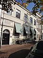
Category:Oosthaven 17, Gouda
Jump to navigation
Jump to search
| Object location | | View all coordinates using: OpenStreetMap |
|---|
 | |||||
| Upload media | |||||
| Instance of | |||||
|---|---|---|---|---|---|
| Location | Gouda, South Holland, Netherlands | ||||
| Street address |
| ||||
| Located on street |
| ||||
| Heritage designation |
| ||||
 | |||||
LINK De Réunie
|
This is a category about rijksmonument number 16884
|
| Address |
|
Subcategories
This category has only the following subcategory.
Media in category "Oosthaven 17, Gouda"
The following 11 files are in this category, out of 11 total.
-
 2011-09-28 Gouda 096.JPG 2,736 × 3,648; 3.59 MB
-
 2011-09-28 Gouda 097.JPG 2,736 × 3,648; 3.27 MB
-
 2011-09-28 Gouda 098.JPG 3,648 × 2,736; 3.76 MB
-
 De Réunie, Oosthaven, Gouda.jpg 1,547 × 1,545; 382 KB
-
 Dirck Volkertsz Coornhert - Oosthaven 17 2801 PC Gouda Netherlands.jpg 1,500 × 2,000; 722 KB
-
 Overzicht gevelwand - Gouda - 20082645 - RCE.jpg 1,200 × 948; 211 KB
-
 Overzicht voorgevel - Gouda - 20082662 - RCE.jpg 1,200 × 953; 223 KB
-
 Overzicht voorgevels - Gouda - 20358508 - RCE.jpg 1,197 × 1,200; 328 KB
-
 Overzicht voorgevels vanaf overzijde water - Gouda - 20358563 - RCE.jpg 1,178 × 1,200; 347 KB
-
 Overzicht voorgevels, vanaf overzijde water - Gouda - 20358560 - RCE.jpg 1,185 × 1,200; 327 KB
-
 Voorgevels - Gouda - 20082659 - RCE.jpg 1,200 × 804; 200 KB


