Category:Oosthaven 52, Gouda
Jump to navigation
Jump to search
| Object location | | View all coordinates using: OpenStreetMap |
|---|
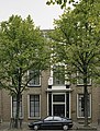
house in Gouda, Netherlands  | |||||
| Upload media | |||||
| Instance of | |||||
|---|---|---|---|---|---|
| Location | Gouda, South Holland, Netherlands | ||||
| Street address |
| ||||
| Located on street |
| ||||
| Heritage designation |
| ||||
 | |||||
|
This is a category about rijksmonument number 16894
|
| Address |
|
Media in category "Oosthaven 52, Gouda"
The following 8 files are in this category, out of 8 total.
-
 Herenhuis - Gouda - 20082682 - RCE.jpg 866 × 1,200; 217 KB
-
 Ingangspartij - Gouda - 20082684 - RCE.jpg 874 × 1,200; 313 KB
-
 Oosthaven 52 Gouda.jpg 442 × 582; 287 KB
-
 Oosthaven 52 in Gouda.jpg 2,253 × 2,147; 3.61 MB
-
 Oosthaven 52, Gouda.jpg 2,048 × 3,072; 3.8 MB
-
 Overzicht - Gouda - 20082683 - RCE.jpg 804 × 1,200; 232 KB
-
 Overzicht toegangsdeur met pronkrisaliet - Gouda - 20366663 - RCE.jpg 1,200 × 1,200; 362 KB
-
 Overzicht van de voorgevels - Gouda - 20379891 - RCE.jpg 1,200 × 1,191; 334 KB


