Category:OpenStreetMap maps of Derbyshire
Jump to navigation
Jump to search
Media in category "OpenStreetMap maps of Derbyshire"
The following 17 files are in this category, out of 17 total.
-
 Burton & Swadlincote Green Belt map.svg 1,042 × 1,042; 2.31 MB
-
 Denby.jpg 1,828 × 995; 268 KB
-
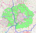
 Derbyshire & Midlands green belts.svg 1,235 × 1,667; 3.83 MB
-
 Location map United Kingdom Derby Central.png 2,047 × 1,945; 3.04 MB
-
 Longdendale Chain.png 1,287 × 646; 313 KB
-
 Nottingham & Derby Green Belt.svg 1,912 × 1,770; 4.13 MB
-
 River Etherow map.png 1,084 × 576; 301 KB
-
 River Kinder map.png 1,267 × 601; 161 KB
-
 River Sett map.png 1,035 × 605; 285 KB
-
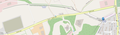 Steeple Grange Light Railway (OpenStreetMap).png 1,378 × 401; 138 KB
-
 Trent & Mersey Canal map.png 1,152 × 855; 1.45 MB
-
 UK Amber Valley District 2024 Map.svg 1,122 × 1,039; 16.22 MB
-
 UK Bolsover District 2024 Map.svg 748 × 1,001; 12.52 MB
-
 UK Erewash District 2024 Map.svg 993 × 958; 9.24 MB
-
 UK High Peak District 2024 Map.svg 795 × 1,024; 13.94 MB
-
 UK North East Derbyshire District 2024 Map.svg 905 × 1,015; 14.5 MB
-
 UK South Derbyshire District 2024 Map.svg 1,122 × 1,039; 18.74 MB


.png)