Category:OpenStreetMap maps of Rotterdam
Jump to navigation
Jump to search
Media in category "OpenStreetMap maps of Rotterdam"
The following 18 files are in this category, out of 18 total.
-
 Approx location of Kromme Zandweg.png 754 × 500; 589 KB
-
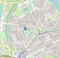
 Binnenrotte Rotterdam Centre.jpg 787 × 503; 98 KB
-
 Europoort osm.png 1,345 × 678; 741 KB
-
 Haringvliet Location osm.png 898 × 662; 238 KB
-
 Justus van Effen OSM 2017.png 444 × 527; 234 KB
-
 Land van Hoboken map.png 644 × 738; 431 KB
-
 Location map Rotterdam.png 1,327 × 761; 1.8 MB
-
 Markthal Rotterdam, géolococ.jpg 872 × 505; 108 KB
-
 Nieuwe Maas osm.png 1,306 × 476; 781 KB
-
 Rotterdam Ajaxstraat.png 894 × 747; 548 KB
-
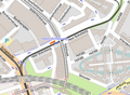
 Rotterdam Centrum and Feijenoord, OSM.png 476 × 373; 276 KB
-
 Rotterdam Charlois Goereestraat.jpg 846 × 668; 219 KB
-
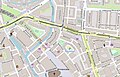
 Rotterdam Heer Bokelweg OSM.png 550 × 403; 312 KB
-
 Rotterdam Lange Hilleweg.png 1,195 × 751; 1.45 MB
-
 Rotterdam Sluisjesdijk.png 1,166 × 803; 855 KB
-
 RotterdamCentrum.png 911 × 918; 1.17 MB
-
 Spangen, Rotterdam- 2017.png 537 × 515; 407 KB
-
 Spoorlijn Utrecht - Rotterdam.png 1,612 × 1,024; 2.75 MB


