Category:OpenStreetMap maps of the Isle of Wight
Jump to navigation
Jump to search
Media in category "OpenStreetMap maps of the Isle of Wight"
The following 10 files are in this category, out of 10 total.
-
 Island Line, Isle of Wight.png 1,792 × 1,719; 1.44 MB
-
 1908 Olympic Course Area, Ryde.png 483 × 599; 67 KB
-
 Bembridge map.png 890 × 856; 246 KB
-
 Island Line map.png 786 × 665; 397 KB
-
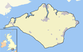 Isle of Wight outline map with UK.png 907 × 574; 96 KB
-
 IsleOfWight2022OSM.png 6,666 × 4,437; 13.87 MB
-
 IWSR OSM.JPG 741 × 469; 54 KB
-
 Map of the IoW.jpg 1,040 × 674; 86 KB
-
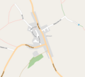
 Newport map.png 909 × 1,004; 293 KB
-
 Whitwell map.png 675 × 611; 63 KB


