Category:Oregon Country
Jump to navigation
Jump to search
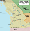
English: The Oregon Country — an American term, the British used the Columbia District, referring to the disputed ownership region of the Pacific Northwest of North America.
- Occupied by British and French Canadian fur traders since 1790s, American settlers from the mid-1830s, and finally resolved by the Oregon Treaty of 1846.
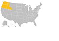
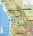
- It included all of present day Oregon, Washington, and Idaho, and parts of British Columbia, Montana, and Wyoming.
Early 19th century US fur trade district in North America | |||||
| Upload media | |||||
| Instance of | |||||
|---|---|---|---|---|---|
| Location | Washington, Pacific Northwest, Washington, Pacific States Region | ||||
 | |||||
Subcategories
This category has the following 15 subcategories, out of 15 total.
*
A
- George Abernethy (5 F)
B
- François Norbert Blanchet (2 F)
C
- Cayuse War (2 F)
F
- Fort Hall (20 F)
G
H
- Wilson Price Hunt (3 F)
L
- London Convention (1818) (4 F)
M
- Methodist Mission in Oregon (5 F)
O
P
- Samuel Parker (missionary) (3 F)
- Francis Pettygrove (9 F)
T
- Tshimakain Mission (12 F)
Media in category "Oregon Country"
The following 37 files are in this category, out of 37 total.
-
 OregonCountry.jpg 1,097 × 769; 31 KB
-
 1841 map of the Oregon Territory.jpg 322 × 218; 23 KB
-
 Acquisition of Oregon - and the long suppressed evidence about Marcus Whitman (IA acquisitionofore01mars).pdf 897 × 1,379, 462 pages; 32.31 MB
-
 BeaverCoins.JPG 701 × 709; 130 KB
-
 BeaverCoins.png 3,894 × 3,939; 144 KB
-
 Boones Ferry landing.JPG 2,059 × 1,849; 2.41 MB
-
 Boston, the place and the people (1903) (14577584399).jpg 2,800 × 1,835; 384 KB
-
 Columbia Ship Coins 1787.jpg 528 × 267; 43 KB
-
 Daniel H. Lownsdale.png 230 × 302; 75 KB
-
 Fort George.jpg 584 × 359; 37 KB
-
 Fort Umpqua Reproduction.jpg 1,000 × 369; 112 KB
-
 HillsboroDavidHill.JPG 1,288 × 966; 1.39 MB
-
 J. Quinn Thornton.jpg 971 × 1,217; 147 KB
-
 JesseQuinnThornton.png 300 × 382; 119 KB
-
 John Baptiste Charles Lucas from Centennial History of Oregon.png 606 × 918; 629 KB
-
 Luther Elkins.jpg 175 × 216; 4 KB
-
 Map of the Oregon Territory by the U. S. Ex. Ex.png 7,000 × 4,843; 62 MB
-
 Simon Metcalf 1790 signature.jpg 453 × 119; 20 KB
-
 Oregon boundary dispute map.PNG 606 × 599; 106 KB
-
 Oregon Country map-fr.svg 932 × 1,024; 4.57 MB
-
 Oregon Country map-it.svg 932 × 1,024; 2.56 MB
-
 Oregon people from Centennial History.png 1,495 × 2,286; 3.04 MB
-
 Oregon provisional districts 1843.jpg 1,091 × 737; 148 KB
-
 Oregon Provisional Government Seal.png 246 × 250; 33 KB
-
 Oregon.jpg 1,097 × 769; 31 KB
-
 Oregoncountry.png 1,000 × 1,019; 1.25 MB
-
 Oregoncountry2.png 992 × 1,011; 1.04 MB
-
 Oregonrussell.jpg 1,056 × 750; 98 KB
-
 Organic Laws of Oregon.png 2,553 × 2,000; 313 KB
-
 Pacific-Northwest.jpg 10,339 × 7,014; 44.2 MB
-
 Provisional Government of Oregon map.png 487 × 315; 33 KB
-
 Provisional Government of Oregon officers.png 2,003 × 3,123; 9.51 MB
-
 Ramsay Crooks.png 1,738 × 2,044; 6.38 MB
-
 Russell Farnham.png 528 × 838; 431 KB
-
 United States 1818-10-1818-12.png 1,000 × 677; 115 KB
-
 Whitman Mission.png 743 × 429; 259 KB
-
 William Fraser Tolmie.png 200 × 275; 59 KB


_(14577584399).jpg)


