Category:Ornunga kyrka
Jump to navigation
Jump to search
| Object location | | View all coordinates using: OpenStreetMap |
|---|
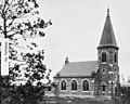
church building in Vårgårda Municipality, Västra Götaland County, Sweden  | |||||
| Upload media | |||||
| Instance of | |||||
|---|---|---|---|---|---|
| Location | Vårgårda Municipality, Västra Götaland County, Sweden | ||||
| Diocese | |||||
| Has use | |||||
| Occupant |
| ||||
 | |||||
|
This is a category about an ecclesiastical monument in Sweden, number 21300000008452 in the RAÄ buildings database.
|
|
This is a category about a protected building in Sweden, number 21400000549749 in the RAÄ buildings database.
|
Media in category "Ornunga kyrka"
The following 6 files are in this category, out of 6 total.
-
 Ornunga kyrka - KMB - 16000200163784.jpg 844 × 600; 126 KB
-
 Ornunga kyrka juni 2021 N.jpg 4,000 × 2,250; 2.31 MB
-
 Ornunga kyrka juni 2021 S.jpg 4,000 × 2,250; 2.29 MB
-
 Ornunga kyrka old1.jpg 753 × 600; 82 KB
-
 Ornunga kyrka.JPG 2,232 × 3,450; 1.95 MB
-
 Ornunga nya kyrka.JPG 2,541 × 1,990; 3.16 MB


Categories:
- Adrian C. Peterson
- Built in Vårgårda Municipality in 1905
- Churches in the Diocese of Skara
- Churches in Vårgårda Municipality
- Churches in Västergötland
- Churches in Västra Götaland County built in 1905
- Gäsene härad
- Gray churches in Sweden
- Listed churches in Vårgårda Municipality
- Romanesque revival stone churches in Västra Götaland County