Category:Osiedle Montwiłła-Mireckiego
Jump to navigation
Jump to search
| Object location | | View all coordinates using: OpenStreetMap |
|---|
.jpg) | |||||
| Upload media | |||||
| Instance of | |||||
|---|---|---|---|---|---|
| Named after | |||||
| Location | Łódź, Łódź Voivodeship, Poland | ||||
| Street address |
| ||||
| Heritage designation |
| ||||
| Inception |
| ||||
 | |||||
Pages in category "Osiedle Montwiłła-Mireckiego"
This category contains only the following page.
Media in category "Osiedle Montwiłła-Mireckiego"
The following 50 files are in this category, out of 50 total.
-
 Katarzyna Kobro.jpg 254 × 350; 28 KB
-
 Mireckiego-archiwalne101.jpg 400 × 303; 97 KB
-
 Mireckiego-archiwalne200.jpg 399 × 248; 76 KB
-
 MireckiegoArchiwalne11.jpg 400 × 296; 42 KB
-
 Os.Mireckiego-Archiwalne1000.jpg 531 × 354; 33 KB
-
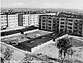
 Osiedle Montwiłła-Mireckiego w Łodzi (1).jpg 3,456 × 2,592; 3 MB
-
 Osiedle Montwiłła-Mireckiego w Łodzi (10).jpg 3,456 × 2,592; 3.15 MB
-
 Osiedle Montwiłła-Mireckiego w Łodzi (11).jpg 3,456 × 2,592; 2.99 MB
-
 Osiedle Montwiłła-Mireckiego w Łodzi (12).jpg 3,456 × 2,592; 3.04 MB
-
 Osiedle Montwiłła-Mireckiego w Łodzi (13).jpg 3,456 × 2,592; 3.23 MB
-
 Osiedle Montwiłła-Mireckiego w Łodzi (14).jpg 3,456 × 2,592; 2.95 MB
-
 Osiedle Montwiłła-Mireckiego w Łodzi (15).jpg 3,456 × 2,592; 3.15 MB
-
 Osiedle Montwiłła-Mireckiego w Łodzi (16).jpg 3,456 × 2,592; 3.05 MB
-
 Osiedle Montwiłła-Mireckiego w Łodzi (17).jpg 3,456 × 2,592; 2.94 MB
-
 Osiedle Montwiłła-Mireckiego w Łodzi (18).jpg 3,456 × 2,592; 3.05 MB
-
 Osiedle Montwiłła-Mireckiego w Łodzi (19).jpg 3,456 × 2,592; 3.21 MB
-
 Osiedle Montwiłła-Mireckiego w Łodzi (2).jpg 3,456 × 2,592; 2.83 MB
-

-
 Osiedle Montwiłła-Mireckiego w Łodzi (21), Szkoła Podstawowa nr 40 przy ul. Praussa.jpg 3,456 × 2,592; 3.08 MB
-
 Osiedle Montwiłła-Mireckiego w Łodzi (22).jpg 3,456 × 2,592; 3.03 MB
-
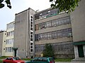
 Osiedle Montwiłła-Mireckiego w Łodzi (23), Biblioteka.jpg 3,456 × 2,592; 2.96 MB
-
 Osiedle Montwiłła-Mireckiego w Łodzi (24), XVIII Liceum Ogólnokształcące przy ul. Perla.jpg 3,456 × 2,592; 3.22 MB
-
 Osiedle Montwiłła-Mireckiego w Łodzi (25).jpg 3,456 × 2,592; 2.97 MB
-
 Osiedle Montwiłła-Mireckiego w Łodzi (26).jpg 3,456 × 2,592; 2.96 MB
-
 Osiedle Montwiłła-Mireckiego w Łodzi (27).jpg 3,456 × 2,592; 3.07 MB
-
 Osiedle Montwiłła-Mireckiego w Łodzi (28).jpg 3,456 × 2,592; 3.32 MB
-
 Osiedle Montwiłła-Mireckiego w Łodzi (29), Przedszkole przy ul. Daniłowskiego.jpg 3,456 × 2,592; 3.08 MB
-
 Osiedle Montwiłła-Mireckiego w Łodzi (3).jpg 3,456 × 2,592; 3.04 MB
-
 Osiedle Montwiłła-Mireckiego w Łodzi (30).jpg 3,456 × 2,592; 3.27 MB
-
 Osiedle Montwiłła-Mireckiego w Łodzi (31).jpg 3,456 × 2,592; 3.22 MB
-
 Osiedle Montwiłła-Mireckiego w Łodzi (32).jpg 3,456 × 2,592; 3.05 MB
-
 Osiedle Montwiłła-Mireckiego w Łodzi (33), siedziba Rady Osiedla przy ul. Perla.jpg 3,456 × 2,592; 3.24 MB
-
 Osiedle Montwiłła-Mireckiego w Łodzi (34).jpg 3,456 × 2,592; 3.1 MB
-
 Osiedle Montwiłła-Mireckiego w Łodzi (35).jpg 3,456 × 2,592; 3.19 MB
-
 Osiedle Montwiłła-Mireckiego w Łodzi (36).jpg 3,456 × 2,592; 3.1 MB
-
 Osiedle Montwiłła-Mireckiego w Łodzi (37).jpg 3,456 × 2,592; 3.01 MB
-
 Osiedle Montwiłła-Mireckiego w Łodzi (38), plan osiedla.jpg 3,456 × 2,592; 3.05 MB
-

-
 Osiedle Montwiłła-Mireckiego w Łodzi (4).jpg 3,456 × 2,592; 3 MB
-

-

-

-
 Osiedle Montwiłła-Mireckiego w Łodzi (43).jpg 3,456 × 2,592; 3.01 MB
-
 Osiedle Montwiłła-Mireckiego w Łodzi (44), Przychodnia.jpg 3,456 × 2,592; 2.97 MB
-
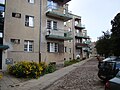
 Osiedle Montwiłła-Mireckiego w Łodzi (5).jpg 3,456 × 2,592; 2.75 MB
-
 Osiedle Montwiłła-Mireckiego w Łodzi (6).jpg 3,456 × 2,592; 3.17 MB
-
 Osiedle Montwiłła-Mireckiego w Łodzi (7).jpg 3,456 × 2,592; 3.11 MB
-
 Osiedle Montwiłła-Mireckiego w Łodzi (8).jpg 3,456 × 2,592; 3.08 MB
-
 Osiedle Montwiłła-Mireckiego w Łodzi (9).jpg 3,456 × 2,592; 2.91 MB
-
 OsiedleMireckiegoarchiwalne.jpg 550 × 418; 41 KB


.jpg)
.jpg)
.jpg)
.jpg)
.jpg)
.jpg)
.jpg)
.jpg)
.jpg)
.jpg)
.jpg)
,_siedziba_Okr%C4%99gowej_Komisji_Egzaminacyjnej_przy_ul._Praussa.jpg)
,_Szko%C5%82a_Podstawowa_nr_40_przy_ul._Praussa.jpg)
.jpg)
,_Biblioteka.jpg)
,_XVIII_Liceum_Og%C3%B3lnokszta%C5%82c%C4%85ce_przy_ul._Perla.jpg)
.jpg)
.jpg)
.jpg)
.jpg)
,_Przedszkole_przy_ul._Dani%C5%82owskiego.jpg)
.jpg)
.jpg)
.jpg)
.jpg)
,_siedziba_Rady_Osiedla_przy_ul._Perla.jpg)
.jpg)
.jpg)
.jpg)
.jpg)
,_plan_osiedla.jpg)
,_tablice_na_%C5%9Bcianie_domu_przy_ul._Srebrzy%C5%84skiej_75.jpg)
.jpg)
,_tablica_na_%C5%9Bcianie_domu_przy_ul._Srebrzy%C5%84skiej_75.jpg)
,_tablica_na_%C5%9Bcianie_domu_przy_ul._Srebrzy%C5%84skiej_75.jpg)
,_tablica_upami%C4%99tniaj%C4%85ca_Katarzyn%C4%99_Kobro_i_W%C5%82adys%C5%82awa_Strzemi%C5%84skiego,_umieszczona_na_%C5%9Bcianie_domu_przy_ul._Srebrzy%C5%84skiej_75.jpg)
.jpg)
,_Przychodnia.jpg)
.jpg)
.jpg)
.jpg)
.jpg)
.jpg)
