Category:Ottenby kungsgård
Jump to navigation
Jump to search
| Object location | | View all coordinates using: OpenStreetMap |
|---|
building in Sweden   | |||||
| Upload media | |||||
| Instance of | |||||
|---|---|---|---|---|---|
| Location | Ottenby, Mörbylånga Municipality, Kalmar County, Sweden | ||||
| Has use | |||||
| Heritage designation |
| ||||
| Inception |
| ||||
 | |||||
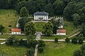
Svenska: Ottenby kungsgård är en herrgård i Ås socken, Mörbylånga kommun, belägen på Ölands sydspets.
|
This is a category about a historic building in Sweden, number 21300000012569 in the RAÄ buildings database.
|
Media in category "Ottenby kungsgård"
The following 14 files are in this category, out of 14 total.
-
 0138Ottenby.jpg 5,760 × 3,597; 5.11 MB
-
 0329Ottenby kungsgård.jpg 3,166 × 2,081; 559 KB
-
 Orminge rör - KMB - 16000300031061.jpg 768 × 512; 82 KB
-
 Ottenby kungsgård - KMB - 16001000054006.jpg 780 × 530; 54 KB
-
 Ottenby kungsgård11.jpg 5,868 × 3,912; 6.25 MB
-
 Ottenby Nature Reserve grazing Gotland sheep Öland Kalmar County Sweden 01.jpg 5,222 × 3,199; 3.73 MB
-
 Ottenby Nature Reserve grazing Gotland sheep Öland Kalmar County Sweden 02.jpg 4,032 × 3,024; 5.62 MB
-
 Ottenby Nature Reserve grazing Gotland sheep Öland Kalmar County Sweden 03.jpg 5,472 × 3,647; 5.32 MB
-
 Ottenby Nature Reserve grazing Gotland sheep Öland Kalmar County Sweden 05.jpg 5,301 × 3,361; 3.8 MB
-
 Ottenby Nature Reserve grazing Gotland sheep Öland Kalmar County Sweden 06.jpg 5,471 × 3,406; 4.9 MB
-
 Ottenby Nature Reserve grazing Gotland sheep Öland Kalmar County Sweden 07.jpg 5,471 × 2,973; 3.53 MB
-
 OttenbyKungsgård160727.jpg 5,184 × 3,456; 7.41 MB
-
 OttenbyKungsgård160727avstånd.jpg 5,184 × 3,456; 9.26 MB
-
 Småland Öland Ottenby Kungsgård430.jpg 3,166 × 2,081; 682 KB


