Category:Oud Aalden 20, Aalden
Jump to navigation
Jump to search
| Object location | | View all coordinates using: OpenStreetMap |
|---|
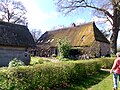
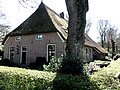
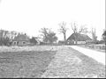
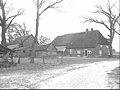
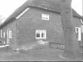
farmhouse in Coevorden, Netherlands  | |||||
| Upload media | |||||
| Instance of | |||||
|---|---|---|---|---|---|
| Location | Aalden, Coevorden, Drenthe, Netherlands | ||||
| Street address |
| ||||
| Located on street |
| ||||
| Heritage designation |
| ||||
 | |||||
|
This is a category about rijksmonument number 41528
|
| Address |
|
Media in category "Oud Aalden 20, Aalden"
The following 13 files are in this category, out of 13 total.
-
 Boerderij met bijgebouwen nr. 322-29 - Aalden - 20487422 - RCE.jpg 1,200 × 900; 177 KB
-
 Boerderij met bijgebouwen nr. 322-30 - Aalden - 20487423 - RCE.jpg 1,200 × 900; 153 KB
-
 Boerderij met bijgebouwen nr. 322-31 - Aalden - 20487424 - RCE.jpg 1,200 × 900; 115 KB
-
 Oud Aalden 21 v1.jpg 4,608 × 3,456; 3.59 MB
-
 Oud Aalden 21 v2.jpg 4,537 × 3,403; 3.66 MB
-
 Overzicht nr.20-21 - Aalden - 20003285 - RCE.jpg 1,200 × 802; 281 KB
-
 Voor- en zijgevel nr. 322-26 - Aalden - 20487419 - RCE.jpg 1,200 × 900; 120 KB
-
 Voor- en zijgevel nr. 322-27 - Aalden - 20487420 - RCE.jpg 1,200 × 900; 141 KB
-
 Vooraanzicht - Aalden - 20228268 - RCE.jpg 1,200 × 807; 256 KB
-
 Zij- en achtergevel nr. 322-28 - Aalden - 20487421 - RCE.jpg 1,200 × 900; 124 KB
-
 Zij- en voorgevel nr. 322-32 - Aalden - 20487426 - RCE.jpg 1,200 × 900; 134 KB
-
 Zij- en voorgevel nr. 322-33 - Aalden - 20487425 - RCE.jpg 1,200 × 900; 120 KB
-
 Zij- en voorgevel nr. 322-35 - Aalden - 20487418 - RCE.jpg 1,200 × 900; 125 KB


